Derby to Loughborough
24.9 miles (40 km)
![]()
![]() Follow National Cycle Route 6 from Derby to Loughborough. Much of this route follows off road paths and tracks including a pleasant stretch along the River Derwent at the start. This section takes you past Pride Park football stadium and also through Alvaston Park. You then pick up the Cloud Trail along a dismantled railway before another waterside stretch along the Trent & Mersey Canal and then across the River Trent. You then enter Leicestershire passing by the villages of Wilson and Breedon on the Hill and through some lovey countryside on the approach to Loughborough.
Follow National Cycle Route 6 from Derby to Loughborough. Much of this route follows off road paths and tracks including a pleasant stretch along the River Derwent at the start. This section takes you past Pride Park football stadium and also through Alvaston Park. You then pick up the Cloud Trail along a dismantled railway before another waterside stretch along the Trent & Mersey Canal and then across the River Trent. You then enter Leicestershire passing by the villages of Wilson and Breedon on the Hill and through some lovey countryside on the approach to Loughborough.
Derby to Loughborough Ordnance Survey Map  - view and print off detailed OS map
Derby to Loughborough Open Street Map  - view and print off detailed map
Derby to Loughborough OS Map  - Mobile GPS OS Map with Location tracking
Derby to Loughborough Open Street Map  - Mobile GPS Map with Location tracking
Cycle Routes and Walking Routes Nearby
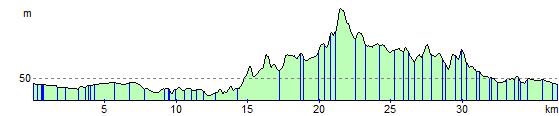
Elevation Profile