Miners Way Cycle Trail
29.8 miles (48 km)
![]()
![]() This circular cycle route has been created by The White Cliffs Countryside Project and accompanies the Miner's Way Walking Trail. The trail passes through beautiful Kent countryside linking a number of interesting mining villages.
This circular cycle route has been created by The White Cliffs Countryside Project and accompanies the Miner's Way Walking Trail. The trail passes through beautiful Kent countryside linking a number of interesting mining villages.
The route begins and ends at Sandwich and visits Woodnesborough, Eastry and Eyethorne with splendid views of the North Downs as you go.
Please click here for more information
Miners Way Cycle Trail Ordnance Survey Map  - view and print off detailed OS map
Miners Way Cycle Trail Open Street Map  - view and print off detailed map
Miners Way Cycle Trail OS Map  - Mobile GPS OS Map with Location tracking
Miners Way Cycle Trail Open Street Map  - Mobile GPS Map with Location tracking
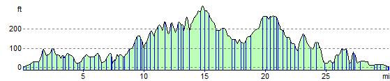
Elevation Profile