South Somerset Cycle Route - Castle Cary to Langport
![]()
![]() This route follows part of the South Somerset Cycle route - an 80 mile ride around this beautiful part of the country.
This route follows part of the South Somerset Cycle route - an 80 mile ride around this beautiful part of the country.
Much of the South Somerset Cycle route is coincident with the National Cycle Network and is therefore covered by other routes on the site. This section however, runs from Castle Cary to Langport exclusivley on the SSC.
The ride is signed for most of the way and follows a series of delightful country lanes. You will pass Keinton Mandeville, Charlton Adam and Somerton with its 17th century market square and outstanding historical architecture.
In Langport you can link up with National Cycle Route 339 which will take you to Bridgwater via the River Parret and the historic Burrow Mump.
Please click here for more information
South Somerset Cycle Route - Castle Cary to Langport Ordnance Survey Map  - view and print off detailed OS map
South Somerset Cycle Route - Castle Cary to Langport Open Street Map  - view and print off detailed map
South Somerset Cycle Route - Castle Cary to Langport OS Map  - Mobile GPS OS Map with Location tracking
South Somerset Cycle Route - Castle Cary to Langport Open Street Map  - Mobile GPS Map with Location tracking
Cycle Routes and Walking Routes Nearby
Photos

Somerton: Market Square

The Quarry Inn, Keinton Mandeville
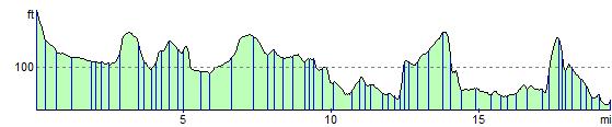
Elevation Profile