Sticklepath Cycle Route
28.6 miles (46 km)
![]()
![]() This circular route takes you through some splendid Devon countryside around Okehampton and Sticklepath.
This circular route takes you through some splendid Devon countryside around Okehampton and Sticklepath.
You first head north from Sticklepath to Hatherleigh, enjoying a stretch along the River Taw before a wooded section through Abbeyford Woods. You then cross the River Okement and continue through Honeychurch and Sampford Courtenay.
The final stretch takes you back to Sticklepath through Taw Green and South Zeal with more fine views of the River Taw.
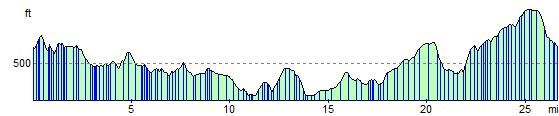
The ride takes place on a series of country lanes and involves a few challenging climbs.
Please click here for more information
Sticklepath Cycle Route Ordnance Survey Map  - view and print off detailed OS map
Sticklepath Cycle Route Open Street Map  - view and print off detailed map
Sticklepath Cycle Route OS Map  - Mobile GPS OS Map with Location tracking
Sticklepath Cycle Route Open Street Map  - Mobile GPS Map with Location tracking
Cycle Routes and Walking Routes Nearby
Elevation Profile