Ashlett Creek to Calshot Walk
![]()
![]() This walk takes you along the Ashlett Creek from Ashlett to Calshot Castle in Hampshire.
This walk takes you along the Ashlett Creek from Ashlett to Calshot Castle in Hampshire.
The walk starts in the village of Ashlett at the village quay. From here you can pick up a footpath heading south east along the creek to Fawley Power Station and the Calshot Marshes Nature Reserve. The reserve is a great place for birdwatching with large numbers of migratory and over-wintering waders and wildfowl. Look out for Wigeon, Teal, Ringed Plover, Grey Plover, Black-tailed Godwit, Redshank and Dunlin in this area.
After passing the reserve you turn the corner to reach Calshot Castle. This artillery fort constructed by Henry VIII on the Calshot Spit during the 16th century.
You can explore the castle and Calshot Beach before returning to Ashlett on the same paths.
To continue your walking simply head south west along the coast to visit the lovely Lepe Country Park.This coastal park has lovely beach walks and views of the Isle of Wight over the Solent.
Ashlett Creek to Calshot Walk Ordnance Survey Map  - view and print off detailed OS map
Ashlett Creek to Calshot Walk Open Street Map  - view and print off detailed map
Ashlett Creek to Calshot Walk OS Map  - Mobile GPS OS Map with Location tracking
Ashlett Creek to Calshot Walk Open Street Map  - Mobile GPS Map with Location tracking
Further Information and Other Local Ideas
Just to the west there's the lovely Exbury Gardens to explore. There's 200 acres of flowers and rare plants with good surfaced footpaths provided.
For more walking ideas in the area see the Hampshire Walks, New Forest Walks page.
Cycle Routes and Walking Routes Nearby
Photos
Victoria Quay and Ashlett Mill. Looking towards Ashlett Mill on the restored Victoria Quay. The mill is a three storey brick building with a tiled mansard roof, rebuilt in 1816. It is now home to the Ashlett Club, part of the Waterside Sports and Social Club.
Ponies south of ESSO sailing club, Ashlett Creek. These ponies are grazing the field on the edge of the saltmarsh at the creek. Beyond the animals is the fenced boat pound of the ESSO sailing club.
Edge of Calshot Marshes. The bollards in the foreground are two of a series that stretch from the power station fence down to the shore. In the far distance is the Marine Terminal of the ESSO oil refinery.
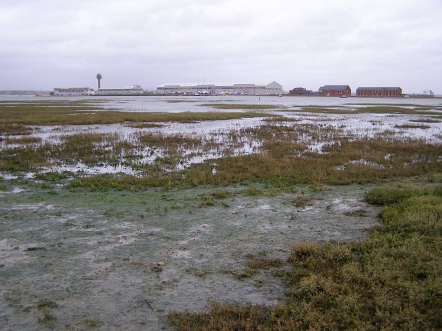
Calshot Marshes nature reserve. Looking across Calshot Marshes from the path along the shore, towards the end of the spit (with the old hangars and coastguard tower). This is a typical salt marsh, formed in the lee of Calshot Spit at the mouth of Southampton Water.


