Ben Nevis Mountain Track - Easiest Route Map
![]()
![]() Follow the Ben Nevis Mountain Track (or Tourist Route) up Britain's highest mountain on this spectacular walk. The route is also known as the Pony Track and is considered the easiest one up the mountain as it doesn't require climbing equipment or extensive mountaineering experience.
Follow the Ben Nevis Mountain Track (or Tourist Route) up Britain's highest mountain on this spectacular walk. The route is also known as the Pony Track and is considered the easiest one up the mountain as it doesn't require climbing equipment or extensive mountaineering experience.
The walk begins in the Glen Nevis visitor centre car park in the town of Fort William in the Scottish Highlands. The visitor centre has a wealth of advice and information and is well worth visiting particularly if you are not an experience hill climber. This route is the most straightforward path up the mountain but is still strenuous with the upper section particularly rough and stony. As such you should prepare properly for the walk with good walking boots, extra clothing and plenty of food and water. It usually takes 7-10 hours for the ascent and descent so it is best attempted in the summer months when there is plenty of daylight.
After leaving the visitor centre you will cross the River Nevis before starting the climb. As you climb the path you will enjoy spectacular views of Glen Nevis, the Mamores and Stob Ban. You will also cross pretty streams and pass the tranquil Loch Meall. At the summit you will find several memorials, a trig point, and many cairns. The views of the highlands are truly magnificent. You then return to the start point by the same route.
Ben Nevis Mountain Track Ordnance Survey Map  - view and print off detailed OS map
Ben Nevis Mountain Track Open Street Map  - view and print off detailed map
*New* - Walks and Cycle Routes Near Me Map - Waymarked Routes and Mountain Bike Trails>>
Ben Nevis Mountain Track OS Map  - Mobile GPS OS Map with Location tracking
Ben Nevis Mountain Track Open Street Map  - Mobile GPS Map with Location tracking
Further Information and Other Local Ideas
For an easier walk in the area head to the nearby Steall Waterfall. There's a lovely trail here through the beautiful Glen Nevis with riverside trails and the second highest waterfall in Scotland. The falls are located on the southern side of the mountain and have a handy on site car park. There's also the fun wire rope bridge over the Water of Nevis to try!
Head north towards Banavie to pick up the Caledonian Canal and you could visit the splendid Neptune's Staircase. The site is noteworthy as the longest staircase lock flight in Scotland.
Cycle Routes and Walking Routes Nearby
Photos
A view up Glen Nevis from the lower section of the Ben Nevis Mountain Track. The trail offers a diverse array of flora and fauna as it ascends through different altitudinal zones. Starting in the lower woodlands, you'll encounter birch, rowan, and hawthorn trees, which support various bird species and insects. As the path climbs, bracken and heather dominate, interspersed with wildflowers like tormentil, violets, and eyebright during the spring and summer months.
A view south from the Ben Nevis Mountain Track, towards Glen Coe. The peak in the foreground is Stob Ban with the two more distant ridges on either side of Glen Coe.
Originally constructed in the 19th century, the trail was developed to allow easier access to the summit for the growing number of visitors interested in Scotland’s burgeoning outdoor tourism. This period coincided with the Victorian-era fascination with the Highlands, spurred by improved rail travel and the romanticised works of poets like Sir Walter Scott.
Lochan Lunn Da-Bhra visible in a glen to the east of Loch Linnhe.
The path was also used in the 19th century to support scientific research and meteorological observations conducted at the summit. Between 1883 and 1904, a weather observatory was operational on Ben Nevis's summit, staffed year-round. Supplies were transported by ponies using this very track, which was an impressive logistical feat considering the rough terrain.
The Tourist Route. High above Glen Nevis on the euphemistically named 'tourist route' to Ben Nevis, looking North towards Achintee. The path cuts across the western slopes of Meall an t-Suidhe.
Higher up, bog asphodel and sundew thrive in wetter areas, the latter being a carnivorous plant that traps insects. On rocky sections, species such as starry saxifrage and alpine speedwell add splashes of colour. Above 1,000 metres, the harsh conditions limit plant growth, but hardy species like dwarf willow, parsley fern, and rare mosses such as woolly fringe moss persist. The summit hosts lichens like "goblin lights," thriving in its crevices, and moss campion, a resilient plant with vibrant pink blooms.
Walking up Ben Nevis via Tourist Path. The wildlife includes red deer, commonly sighted in lower areas, while mountain hares and ptarmigans adapt to the higher altitudes. Birds such as golden eagles occasionally soar over the landscape, adding to the sense of wilderness. This biodiversity highlights Ben Nevis as an Important Plant Area, recognised for its ecological significance
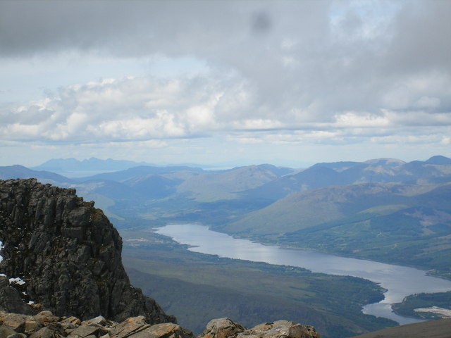
View of the top of the cliffs on the north side of Ben Nevis summit. The extensive view beyond shows Loch Eil pointing directly towards the island of Rum with Eigg just visible in front and to the left. To the right of Rum, on the far horizon, the peaks of South Uist in the Outer Hebrides can be seen - almost 100 miles away.


