Celandine Route OS Map
![]()
![]() Follow the River Pinn from Pinner to Cowley on this nice easy waterside walk through west London.
Follow the River Pinn from Pinner to Cowley on this nice easy waterside walk through west London.
The walk starts at Pinner tube station and follows the river through Ruislip and Hillingdon before finishing on the Grand Union Canal at Cowley.
Look out for flora and fauna on the walk including Kingfishers and Treecreepers and the Lesser Celandine flowers after which the walk is named.
The section around Cowley includes a cycle path which runs past Brunel University.
Celandine Route Ordnance Survey Map  - view and print off detailed OS map
Celandine Route Open Street Map  - view and print off detailed map
*New* - Walks and Cycle Routes Near Me Map - Waymarked Routes and Mountain Bike Trails>>
Celandine Route OS Map  - Mobile GPS OS Map with Location tracking
Celandine Route Open Street Map  - Mobile GPS Map with Location tracking
Pubs/Cafes
There's a nice waterside cafe next to Ruislip Lido, just west of the route. It's a lovely place for rest and refreshment on a fine day.
Further Information and Other Local Ideas
Near the start of the route you can take a slight detour to visit Ruislip Lido. The lido is a popular place for waterside walks with an artificial beach and super Mini gauge railway as well. Bayhurst Wood Country Park and Ruislip Woods are located next to the lido and have some nice peaceful woodland trails to explore on foot or by bike.
The Colne Valley Trail runs just west of the route. This shared cycling and walking trail will take you through the River Colne valley, visiting several pretty lakes and the nearby Denham Country Park on the way.
Cycle Routes and Walking Routes Nearby
Photos

Celandine Way and River Pinn near Pinner. The route is named after the lesser celandine (Ficaria verna), a small, low-growing perennial herb in the buttercup family. This plant features glossy, dark-green, heart-shaped leaves and shiny, yellow star-like flowers with eight to twelve petals. Lesser celandine thrives in damp woodland paths, stream banks, and shady hedgerows, typically flowering between January and April.

River Pinn in Ruislip. Viewed looking upstream from the footbridge connecting Grasmere Avenue and Westcote Rise.

River Pinn. looking towards Swakeleys Road, Ickenham. Along the Celandine Route, walkers can observe a variety of flora and fauna. The path passes through woodlands, meadows, and wetlands, supporting diverse plant life, including wildflowers, grasses, and mature trees. These habitats provide shelter and food for numerous animal species. Birdwatchers may spot species such as kingfishers, herons, and various songbirds. The river and adjacent wetlands are home to amphibians like frogs and toads, as well as mammals such as hedgehogs and foxes. The presence of allotments along the route also attracts wildlife, including slow worms and various bird species, which help control pests.

Swakeleys Park Diamond Jubilee Garden

River Pinn after winter rain. River Pinn downstream of Stratford bridge [A4020], Uxbridge/Hillingdon border.

High water in the River Pinn. Viewed from the perimeter road within the grounds of Brunel University.

Viewed looking downstream from near the Robbie Bell Bridge, the Pinn is a tributary of the River Colne. The water here was very clear.

Packet Boat Marina
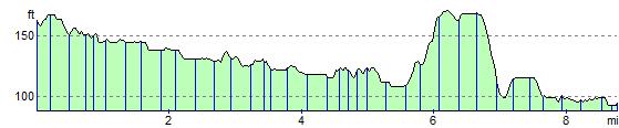
Elevation Profile