Cockerham Sands Walks
![]()
![]() This walk explores the lovely Cockerham Sands on the Lancashire coast. It's a fine place for a bracing walk with excellent views across the Lune Estuary to Sunderland Point. There's also a visit to a historic Scheduled Ancient Monument to enjoy on the way.
This walk explores the lovely Cockerham Sands on the Lancashire coast. It's a fine place for a bracing walk with excellent views across the Lune Estuary to Sunderland Point. There's also a visit to a historic Scheduled Ancient Monument to enjoy on the way.
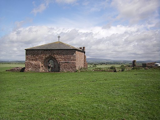
You can start the walk from the car park at Glasson Dock, just to the north of the sands. From here you can pick up the Lancashire Coastal Way and follow the waymarked footpath south along Marsh Lane to the coast at Crook Farm. Continue south and the path will take you Plover Hill and the remains of Cockersand Abbey. The abbey was founded in the 12th century but the only significant remains are the vaulted chapter house which was built in 1230. It is notable as a Grade I listed building and Scheduled Ancient Monument.
The route then continues east past the caravan site to Cockerham village where you can enjoy refreshments at the local inn before returning on the same paths.
Postcode
LA2 0BB - Please note: Postcode may be approximate for some rural locationsCockerham Sands Ordnance Survey Map  - view and print off detailed OS map
Cockerham Sands Open Street Map  - view and print off detailed map
Cockerham Sands OS Map  - Mobile GPS OS Map with Location tracking
Cockerham Sands Open Street Map  - Mobile GPS Map with Location tracking
Pubs/Cafes
The Manor Inn in Cockerham village is a good option for some refreshment on the walk. The pub does a fine Sunday lunch for a very reasonable price. There's also a garden area if the weather is good. You can find them on the Main Street at postcode LA2 0EF.
Dog Walking
The coastal path makes for a fine dog walk. The Manor Inn mentioned above is also dog friendly.
Further Information and Other Local Ideas
Just to the east of Glasson Docks there's the delightful Conder Green to explore. The area includes a nice picnic site, trails along the Lancaster Canal, fine views of the tidal River Conder and a historic old mill restaurant for refreshments afterwards.
Cyclists can pick up the Lancashire Cycleway Northern Loop in the village.
For more walking ideas in the area see the Lancashire Walks page.
Cycle Routes and Walking Routes Nearby
Photos
Ruins at Cockersand Abbey. The rebuilt and preserved Chapter House was only a small part of the Abbey. Much lies buried, and even more was removed after the Dissolution, the stone finding its way into the sea defences and local dwellings. The picture was taken in the region of the North Transept and later Lady Chapel.


