River Cray Walk
![]()
![]() Follow the Cray Riverway on this easy waterside walk through Bromley.
Follow the Cray Riverway on this easy waterside walk through Bromley.
The walk starts off in Orpington at the attractive priory gardens where you'll find the source of the River Cray. You then head north through Sidcup, Bexley and Crayford where you join the River Darent.
The Darent then leads you to the final stretch alongside the River Thames, finishing near Erith.
At the northern end of the route the trail meets with the Darent Valley Path. The trail runs south along the river towards Darenth Country Park and Sevenoaks, passing through the Kent Downs AONB.
Please click here for more information
Cray Riverway Ordnance Survey Map  - view and print off detailed OS map
Cray Riverway Open Street Map  - view and print off detailed map
*New* - Walks and Cycle Routes Near Me Map - Waymarked Routes and Mountain Bike Trails>>
Cray Riverway OS Map  - Mobile GPS OS Map with Location tracking
Cray Riverway Open Street Map  - Mobile GPS Map with Location tracking
Cycle Routes and Walking Routes Nearby
Photos

Priory Pond, Orpington. Although at first sight this might seem a normal municipal park pond, it is in fact the result of a natural spring, being the source of the River Cray. Being a chalk spring, it can run dry in periods of drought, in which case the pond level sinks, and can even dry up altogether, revealing the usual rubbish that such a site seems to attract.

Bend in the River Cray at St Paul's Cray

Five Arch Bridge, River Cray, Sidcup, Kent. The bridge is seen looking northwards from the east bank of the Cray, which above this point spreads out to form an attractive lake.

River Cray at Crayford, Kent. Here the Cray runs through a pleasant garden area near the centre of Crayford.

View along the river from Maiden Lane near Bexley.

Barnes Cray: Railway viaduct over the river. The viaduct carries the railway south of Slade Green station on its way to Dartford over the River Cray here. The river is tidal here as evidenced by the wide height range of the stain marks on the viaduct abutments.

Dartford Creek

River Darent and Thames meet. This is the mouth of the Darent (from which Dartford gets its name) looking across to Purfleet.
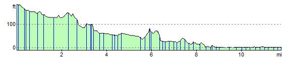
Elevation Profile