East Riding of Yorkshire Heritage Walk
![]()
![]() Follow the East Riding Heritage Way from the Humber Bridge to Filey on this trail through the East Yorkshire countryside. The walk starts with a section along the Humber Estaury from Hessle and heads to Beverley, with its wonderful minster. You continue to Driffield where there is a lovely waterside section along the Driffield Canal. The next stage then takes you to the coast and the seaside resort of Bridlington. The rest of the route then follows the spectacular East Yorkshire coastline, passing Bempton Cliffs with its huge seabird colonies, the lighthouse at Flamborough Head (video below) and the interesting cliff arch at Thornwick Bay before finishing at Filey.
Follow the East Riding Heritage Way from the Humber Bridge to Filey on this trail through the East Yorkshire countryside. The walk starts with a section along the Humber Estaury from Hessle and heads to Beverley, with its wonderful minster. You continue to Driffield where there is a lovely waterside section along the Driffield Canal. The next stage then takes you to the coast and the seaside resort of Bridlington. The rest of the route then follows the spectacular East Yorkshire coastline, passing Bempton Cliffs with its huge seabird colonies, the lighthouse at Flamborough Head (video below) and the interesting cliff arch at Thornwick Bay before finishing at Filey.
East Riding Heritage Way Ordnance Survey Map  - view and print off detailed OS map
East Riding Heritage Way Open Street Map  - view and print off detailed map
East Riding Heritage Way OS Map  - Mobile GPS OS Map with Location tracking
East Riding Heritage Way Open Street Map  - Mobile GPS Map with Location tracking
Pubs/Cafes
On the route you can enjoy refreshments at Thornwick Bay and enjoy wonderful views from the cliff top cafe. The cafe's speciality is locally caught crab which you can enjoy with a glass of wine or cup of tea.
On Flamborough Head you can visit the 19th century North Star Hotel for refreshments. There's fine sea views and an award-winning restaurant renowned for its fresh Flamborough seafood and wild game caught on the Yorkshire Wolds.
Further Information and Other Local Ideas
At the end of the route in Filey you can visit Filey Brigg where there's some fascinating geology and wildlife including whales, seals and dolphins.
Cycle Routes and Walking Routes Nearby
Photos
Bempton Cliffs. Whether viewed from land or from the sea, Bempton Cliffs is a spectacle, particularly so during the breeding season when vast numbers of seabirds are present.
Thornwick Nab and Great Thornwick Bay. Taken from the coastal path around High Holme, this shows Thornwick Nab, with its arch cut into the Chalk, jutting out to sea and stunning Great Thornwick Bay. Eventually the arch will collapse, leaving a pillar (stack) of chalk cut off from the rest of the headland. The beach shingle is predominantly of local flint and chalk, but there are numerous erratic rocks and pebbles released from the boulder clay (which overlies the Chalk) which has fallen/slipped on to the beach and been broken up by the sea. Large boulders of various types are also scattered over the beach.
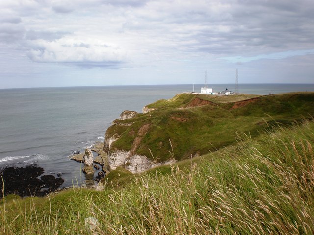
The coastline at Flamborough Head, renowned for its dazzling white chalk cliffs and stacks, with the Fog Signal Station situated on the most easterly point of the headland.
Elevation Profile


