Gordon Way
![]()
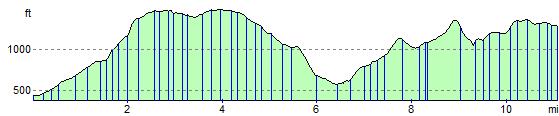
![]() Explore the Bennachie range in Aberdeenshire on this challenging walk. The route starts at the Bennachie Centre and heads west through Bennachie Forest, past Oxen Craig (the highest of the range) to Suie in the west. The views from the Bennachie ridge are stunning.
Explore the Bennachie range in Aberdeenshire on this challenging walk. The route starts at the Bennachie Centre and heads west through Bennachie Forest, past Oxen Craig (the highest of the range) to Suie in the west. The views from the Bennachie ridge are stunning.
To climb to the two highest points in the range try our Bennachie Circular Walk which starts from the visitor centre.
The Gordon Way walk is waymarked with a black and white logo.
Gordon Way Ordnance Survey Map  - view and print off detailed OS map
Gordon Way Open Street Map  - view and print off detailed map
Gordon Way OS Map  - Mobile GPS OS Map with Location tracking
Gordon Way Open Street Map  - Mobile GPS Map with Location tracking
Cycle Routes and Walking Routes Nearby
Photos

Entrance to Bennachie Visitor Centre

The Gouk Stone. Standing stone in the former colony at Bennachie
.jpg)
Gordon Way

Heather Moorland and Gordon Way Footpath. On the horizon is Oxen Craig.

Watch Craig and Heather Moorland

Cairn Boundary Stone on Forestry Commission Boundary

Track on north side of Black Hill

Footpath on Corrie Hill
Elevation Profile