Gower Way Walk Map and GPX
![]()
![]() This walk takes you through the stunning Gower AONB from Penlle'r Castell in the north, to Rhossili on the Gower Peninsula, in the south. The route was inaugurated by the Prince of Wales in 1998 and takes you past a variety of impressive historical sites, including ancient cairns, standing stones and Norman chapels.
This walk takes you through the stunning Gower AONB from Penlle'r Castell in the north, to Rhossili on the Gower Peninsula, in the south. The route was inaugurated by the Prince of Wales in 1998 and takes you past a variety of impressive historical sites, including ancient cairns, standing stones and Norman chapels.
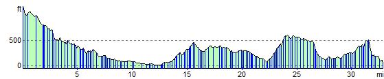
The first section runs from Penlle'r Castell to Gowerton, passing the Lliw Reservoirs, before crossing the River Lliw a Gorseinon.
The second section runs from Gowerton to Penmaen where you can enjoy splendid coastal views of Oxwich Bay.
The final section runs from Penmaen to Rhossili, with a climb to the sandstone ridge of Cefn Bryn where there are more fabulous views of the Gower Peninsula.
At Rhossili you can enjoy wonderful views over Rhossili Bay and Worm's Head. This unusual promontory, is shaped like a giant sea-serpent and marks the most westerly tip of Gower. It is possible to walk to Worm's Head but only when the tide is out so check tide times before if you intend to extend your walk here.
The walk is waymarked with a black, green and yellow disc.
Gower Way Ordnance Survey Map  - view and print off detailed OS map
Gower Way Open Street Map  - view and print off detailed map
*New* - Walks and Cycle Routes Near Me Map - Waymarked Routes and Mountain Bike Trails>>
Gower Way OS Map  - Mobile GPS OS Map with Location tracking
Gower Way Open Street Map  - Mobile GPS Map with Location tracking
Pubs/Cafes
The Gower Inn is located a short distance north east of Penmaen and a good place to stop for refreshments ont the route. There's a good menu and an outdoor seating area to relax in. You can find it in Parkmill at postcode SA3 2EQ.
There's also the delightful Mill Tea Rooms at Parkmill (postcode SA3 2EH).
Further Information and Other Local Ideas
//www.youtube.com/embed/1ukbxQbyznU
Cycle Routes and Walking Routes Nearby
Photos

On Cefn Bryn Ridge Green, purple and yellow mix of colours on top of Cefn Bryn, the long ridge crossing the Gower Peninsula. In the distance is Penmaen.
The route passes through a range of landscapes, from moorland and ancient woodland to saltmarsh and coastal dunes, supporting a rich diversity of flora and fauna.
The inland sections feature heathland with species such as heather, gorse, and bilberry, providing habitat for butterflies like the green hairstreak and grayling. Woodland areas, including those near Penlle’r Castell and Park Wood, contain oak, ash, and hazel, where woodland birds such as nuthatches, great spotted woodpeckers, and tawny owls can be found. The damp, shaded areas support ferns and mosses, while bluebells and wild garlic carpet the woodland floor in spring.

Rhossili Bay. As the trail nears the coast, it crosses saltmarshes and estuaries where sea lavender, thrift, and samphire grow. These areas attract wading birds such as curlews, redshanks, and oystercatchers, alongside wildfowl like shelducks and Brent geese. The dunes around Llangennith and Oxwich Bay are home to rare plants such as dune gentian and sea holly, as well as sand lizards and the scarce dark green fritillary butterfly.

On the Inner Head, Worm's Head. The route is also known for its diverse mammal life. Wild ponies graze the upland commons, while otters are sometimes seen near the River Loughor and estuarine sections. The cliffs and coastal areas provide breeding sites for seabirds, including razorbills, guillemots, and fulmars. Offshore, dolphins and grey seals are often spotted in the waters around Worm’s Head and Rhossili Bay.

North end of Upper Lliw reservoir.

Cairn Above Penmaen. Large megalithic cairn on the eastern end of the Cefn Bryn ridge with view to Three Cliffs Bay. The Gower Way also holds historical interest, passing prehistoric sites such as Arthur’s Stone, a Neolithic burial chamber, and Cefn Bryn, known as the ‘backbone of Gower’. The trail connects with picturesque villages like Reynoldston and Penmaen, while also offering panoramic views of Swansea Bay and the Bristol Channel from high points along the ridge.

Start of the Gower Way on Cefn Bryn
.jpg)
The trail passing through Brynllefrith Forest

Rhossili Bay. A glorious summer view across this beautiful bay which is one of the highlights of the walk.
Elevation Profile