Green Link Walk Map and GPX
![]()
![]() This 15 mile waymarked walk runs from the edge of Epping Forest to Peckham.
This 15 mile waymarked walk runs from the edge of Epping Forest to Peckham.
On the way you will pass a number of famous London landmarks and attractive green spaces. Highlights include the River Lea, the Regent's Canal, Walthamstow Reservoirs, the River Thames, London Fields, Exmouth Market, St. Paul's Cathedral, The Tate Modern and Burgess Park.
The route also links with several other of London's long distance walks including the Capital Ring, Jubilee Greenway, Lea Valley Walk and the Thames Path. You can also pick up the Epping Forest Centenary Walk at the start of the walk.
You can begin the walk in Upper Walthamstow, near St Peter's church. Head west from here and you will soon come to the Walthamstow Reservoirs where there are some nice waterside trails and lots of wildlife to see in the adjacent Walthamstow Marshes Nature Reserve.
From here you continue south to Lea Bridge where you can enjoy views of the River Lea. Just west of here you will come to Hackney Downs a large area of common land in Lower Clapton. The park is a pleasant place for a stroll with facilities including a play area, basketball courts, football pitches and a bowling green.
The route continues south west through Hackney towards Islington where you will cross the Regent's Canal near Angel tube station.
Head south from here and you will pass Clerkenwell and Finsbury before coming to the River Thames where you cross to the southern side.
You'll then pass Lambeth, Newington and the Elephant and Castle station on your way to Burgess Park in Camberwell in the London Borough of Southwark. The park includes a picturesque lake and a number of historic, listed buildings. After passing through the park you will soon come to the end of the walk in Peckham.
Green Link Walk Ordnance Survey Map  - view and print off detailed OS map
Green Link Walk Open Street Map  - view and print off detailed map
*New* - Walks and Cycle Routes Near Me Map - Waymarked Routes and Mountain Bike Trails>>
Green Link Walk OS Map  - Mobile GPS OS Map with Location tracking
Green Link Walk Open Street Map  - Mobile GPS Map with Location tracking
Cycle Routes and Walking Routes Nearby
Photos
The Edge of Epping Forest Walthamstow. Start the walk from here.
The Green Link Walk weaves through an astonishing variety of urban habitats that reveal the rich tapestry of London’s natural heritage. As you move from the ancient, wild fringes of Epping Forest, where towering oaks and hornbeams support a carpet of bluebells and ferns and provide refuge for woodland creatures such as deer, foxes, and bats, into the vibrant wetlands of Walthamstow Marshes, you are treated to a dynamic display of flora and fauna. The marshes, with their gentle reeds, water lilies, and wild grasses, create ideal conditions for a host of waterfowl, amphibians, and insects, while pockets of open grassland along the route burst into color each spring with an array of wildflowers that attract butterflies and dragonflies. Urban parks like London Fields and Burgess Park further enrich the experience with carefully cultivated ornamental trees and garden landscapes that serve as havens for sparrows, starlings, and even the occasional heron gliding over quiet ponds
Reservoir 1, Walthamstow Wetlands. Beyond its natural riches, the walk is interlaced with elements of modern urban regeneration and community spirit, from innovative rain gardens designed to mitigate flooding to striking public art installations and wayfinding that celebrate London’s historical and cultural evolution. This blend of nature and urban design not only offers a feast for the eyes but also a deeper insight into how London is reimagining its green spaces to promote wellbeing, sustainability, and a resilient connection between the city’s past and its future.
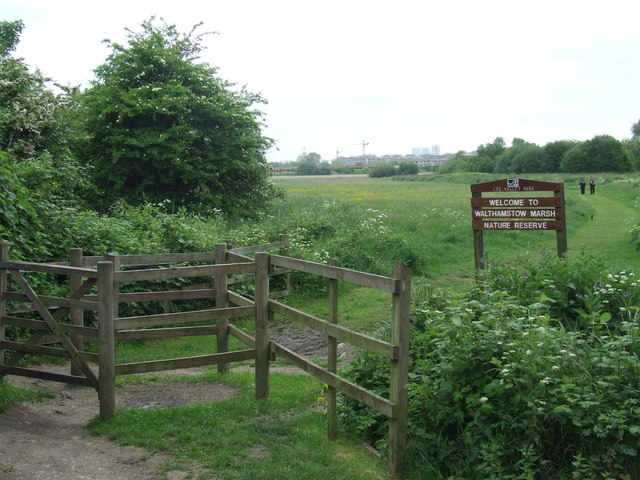
Walthamstow Marshes. Walthamstow Wetlands, a functioning 211-hectare Thames Water reservoir site, serves as the primary water source for 3.5 million people. It doubles as a globally significant nature reserve, offering refuge to a diverse array of wildlife, including rare waterfowl and majestic birds of prey. Featuring varied habitats and landscapes, from densely vegetated scrub-lined banks to expansive vistas overlooking the city, Walthamstow Wetlands retains its status as London's largest fishery. It forms part of the Walthamstow Reservoirs Site of Special Scientific Interest, the Lee Valley Special Protection Area, a Ramsar site of international significance, and the Lee Valley Walthamstow Site of Metropolitan Importance for Nature Conservation.
London Fields. London Fields is one of Hackney’s most popular parks. The park is classified as common land due to its history as a site for grazing animals where they were then transferred to market at Smithfield. The park includes pleasant, large grassy spaces which are surrounded by London Plane trees. It also holds a Green Flag award – which is given annually to the best green spaces in the country.
Burgess Park Lake. Burgess Park, Southwark's largest park at 56 hectares, stretches from Camberwell and Walworth in the west to Peckham and the Old Kent Road in the east. Developed between the 1950s and 1980s, Burgess Park emerged from the Abercrombie Plan for open spaces in 1943. It replaced a landscape once dominated by factories, crowded streets, and the Surrey Canal, heavily bombed during World War II. Named after Councillor Jessie Burgess, Camberwell's inaugural female Mayor in 1973, the park underwent a significant £8m renovation, reopening in 2012. This transformation cemented its status as a community hub, celebrated for its heritage, sports amenities, lake, wildlife, design, horticulture, and barbecue facilities.


