Kew Gardens Walk
![]()
![]() Visit the most popular paid entry garden in the UK on this walk in Greater London. Kew has a series of well laid out footpaths running for several miles around the expansive site. It has the world's largest collection of living plants with a herbarium which has over seven million preserved plant specimens. Highlights include the fantastic Treetop walkway which takes you into the tree canopy of the Kew woodland. The Sackler Crossing bridge across the large lake and the wonderful Bamboo Garden are also must sees. You can virtually explore the gardens using the street view link below!
Visit the most popular paid entry garden in the UK on this walk in Greater London. Kew has a series of well laid out footpaths running for several miles around the expansive site. It has the world's largest collection of living plants with a herbarium which has over seven million preserved plant specimens. Highlights include the fantastic Treetop walkway which takes you into the tree canopy of the Kew woodland. The Sackler Crossing bridge across the large lake and the wonderful Bamboo Garden are also must sees. You can virtually explore the gardens using the street view link below!
The gardens are located on the River Thames so you could extend your walk by picking up the Thames Path and heading towards nearby Richmond or Chiswick. Here you will find the splendid Marble Hill Park. Syon Park is also just opposite and is another good option.
Postcode
TW9 3AB - Please note: Postcode may be approximate for some rural locationsPlease click here for more information
Kew Gardens Ordnance Survey Map  - view and print off detailed OS map
Kew Gardens Open Street Map  - view and print off detailed map
Kew Gardens OS Map  - Mobile GPS OS Map with Location tracking
Kew Gardens Open Street Map  - Mobile GPS Map with Location tracking
Explore the Area with Google Street View 
Further Information and Other Local Ideas
On the other side of the river you can pick up the Grand Union Canal Walk and follow it north to its confluence with the River Brent. Here you can pick up the Brent River Park Walk and follow the riverside trail through Ealing to Perivale. There's some nice riverside parks and a series of weirs on the way.
The popular Crane Park is located nearby in Twickenham. The peaceful park includes an informative visitor centre, cafe, woodland trails along the River Crane, lots of wildlife and the interesting 18th century Shot Tower. Just north of here you can also reach the historic Cranford Country Park on the riverside trail.
For more walking ideas in the area see the London Walks page.
Cycle Routes and Walking Routes Nearby
Photos
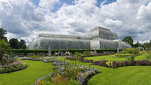
A view across the gardens to the Palm House in Kew Gardens, in London, England. This is a 4 segment panoramic image. Visible in the foreground of the palm house are some of the replicas of the Queen's Beasts: the Yale of Beaufort, the Red Dragon of Wales, the White Horse of Hanover, the Unicorn of Scotland, and the Griffin of Edward III.


