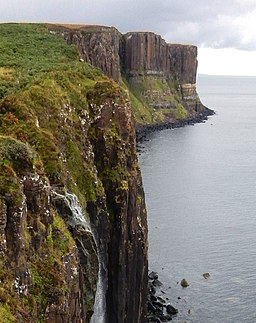
Kilt Rock And Mealt Falls Walk
![]()
![]() This walk on the Isle of Skye visits Kilt Rock and the waterfalls at Loch Mealt on the eastern coast of the island.
This walk on the Isle of Skye visits Kilt Rock and the waterfalls at Loch Mealt on the eastern coast of the island.
You can start the walk from the car parking area on the eastern side of the loch. From here it is a short stroll to the Kilt Rock viewpoint and the waterfall. It's a lovely photogenic spot with the added opportunity of spotting a variety of coastal birds on the imposing cliffs.
To continue your walking in the area head south along the coast to visit another island highlight at the spectacular Old Man of Storr.
Just to the west is the climb to the Quiraing where there are wonderful views over the island.
Postcode
IV51 9JE - Please note: Postcode may be approximate for some rural locationsKilt Rock And Mealt Falls Ordnance Survey Map  - view and print off detailed OS map
Kilt Rock And Mealt Falls Open Street Map  - view and print off detailed map
Kilt Rock And Mealt Falls OS Map  - Mobile GPS OS Map with Location tracking
Kilt Rock And Mealt Falls Open Street Map  - Mobile GPS Map with Location tracking
Further Information and Other Local Ideas
Just north along the coast you will find Duntulm Castle. The 14th century castle sits in a wonderful coastal location with fabulous views of Tulm Bay.
Head south and you can visit the Island's capital at Portree. Here you can pick up the circular Portree Scorrybreac Walk and enjoy views of the picturesque harbour, the colourful buildings of Portree town and out to the Island of Raasay.
Cycle Routes and Walking Routes Nearby
Photos
Kilt Rock. From the top of the 90m high, two tiered cliff that has pleats resembling a kilt. The upper part is columnar basalt, sitting on horizontal beds of sandstone. The Mealt waterfall by the car park and viewpoint in NG5065 can be seen near the centre of the picture. That is the best place to view the Kilt Rock. The cliff edge here is difficult to reach, uneven and very dangerous.


