Landsker Borderlands Trail
![]()
![]() A super circular walk through the Pembrokeshire and Carmarthenshire countryside visting the River Cleddau estuary, the Ogham stones, the Norman castles at Llawhaden and Carew Castle as well as the prehistoric remains at Llawhaden.
A super circular walk through the Pembrokeshire and Carmarthenshire countryside visting the River Cleddau estuary, the Ogham stones, the Norman castles at Llawhaden and Carew Castle as well as the prehistoric remains at Llawhaden.
Part of the trail is used on the Lawrenny Quay and the Daugleddau River Walk. It explores a picturesque peninsula of the Cleddau estuary. You'll also pass close to Carew Castle where there's a splendid circular walk around the delightful mill pond.
Landsker Borderlands Trail Ordnance Survey Map  - view and print off detailed OS map
Landsker Borderlands Trail Open Street Map  - view and print off detailed map
Landsker Borderlands Trail OS Map  - Mobile GPS OS Map with Location tracking
Landsker Borderlands Trail Open Street Map  - Mobile GPS Map with Location tracking
Further Information and Other Local Ideas
For more walking ideas in the area see the Pembrokeshire Coast Walks page.
Cycle Routes and Walking Routes Nearby
Photos

Landsker Borderlands Trail, Coed Howell. The long distance path is seen here as it heads south to its starting point at Whitland. It is a circular route of about 60 miles (100 kms). The Landsker Line is an imaginary line 'separating the Welsh speaking North of Pembrokeshire from its English speaking south'.

Landsker Borderlands Farmland. Wooded area with bike and footpath trails. Farm on left of picture is Danycoed.

River Wenallt. Here the trail crosses a footbridge over the small river Wenallt - more a stream.

Quiet Lane Towards The River Wenallt

Aber Farm, Coed Howell. The farm is in a valley formed by a small watercourse named Afon Gronw.

Stepping stones over the Cresswell. This location is definitely not crossable 24 hours a day as the river is tidal here and the stepping stones are only accessible during low tide. Based on what I could see, they're uncrossable for about 3 hours each high tide making them unusable for about 6 hours in each day. They do form part of the trail.

Ogham stones. One of a number of groups of Ogham stones sited in different parts of Ireland. This particular group is situated Just outside the village of Beaufort in Co.Kerry. The edges of each stone is etched with various markings and were used as an early form of writing or communication.

Footpath to Blaencilgoed Quarries.
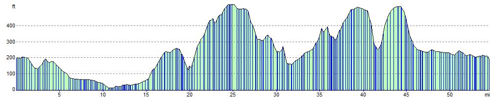
Elevation Profile