Mary Michael Pilgrims Way
![]()
![]() This route begins on the Cornish coast, near Land's end, and passes through Cornwall, Devon and Gloucestershire to finish at Glastonbury. However, the vision is to extend the route to the Norfolk coast in the near future.
This route begins on the Cornish coast, near Land's end, and passes through Cornwall, Devon and Gloucestershire to finish at Glastonbury. However, the vision is to extend the route to the Norfolk coast in the near future.
The walk connects many sites associated with spirituality and Christian pilgrimage incuding
Boscawen-Un - Bronze age stone circle near St Buryan in Cornwall possibly used as a meeting place for druids in the Iron Age
St Michaels Mount - magnificent tidal island located off the Mount's Bay coast of Cornwall and the former site of a monastery.
The Hurlers - three late Neolithic or early Bronze Age stone circles located on Bodmin Moor. Probably the best examples of ceremonial circles in the south west.
Glastonbury - a popular destination for pilgrims in the Middle Ages. Here you will find Glastonbury Tor - a Scheduled Ancient Monument
The walk is waymarked with an oak plaque.
Please click here for more information
Mary Michael Pilgrims Way Ordnance Survey Map  - view and print off detailed OS map
Mary Michael Pilgrims Way Open Street Map  - view and print off detailed map
Mary Michael Pilgrims Way OS Map  - Mobile GPS OS Map with Location tracking
Mary Michael Pilgrims Way Open Street Map  - Mobile GPS Map with Location tracking
Cycle Routes and Walking Routes Nearby
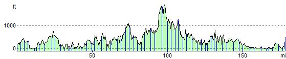
Elevation Profile