GPS Cycle and Walking Routescycle iconwalk icon

South Bank Walk

0.9 miles (1.4 km)

Ordnance Survey Map Open Streetmap This walk takes you along London's famous South Bank visiting Jubilee Gardens, the London Eye, the Southbank Centre, the Royal Festival Hall, and the National Threatre.
It's an interesting section of the Thames Path with several of the city's highlights to enjoy along a short stretch of the river.
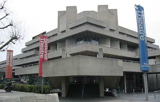
The walk starts off near Waterloo train station in the pretty Jubilee Gardens, next to the London Eye. From here you head north east along the Queen's Walk to the South Bank Centre where there's exhibitions, galleries and concerts to see. The route continues past the Royal Festival Hall, the National Threatre and the ITV studios.

Postcode

SE1 7PB - Please note: Postcode may be approximate for some rural locations

South Bank OS Map Ordnance survey map - Mobile GPS OS Map with Location tracking

South Bank Open Street Map Open Streetmap - Mobile GPS Map with Location tracking

Cycle Routes and Walking Routes Nearby

Photos

London Eye, Big Ben from the southbank centre

This is the house of parliment the centre of UK politics with the London Eye in the foreground, taken from atop the South Bank Centre in central London.

Royal Festival Hall from York Road 2

Royal Festival Hall from York Road

South Bank Centre from Jubilee Bridge, London. - panoramio

South Bank Centre from Jubilee Bridge, London.

Royal National Theatre 2

Royal National Theatre

Video

GPS Files

GPX File

South Bank.gpx (On Desktop:Right Click>Save As. On Ipad/Iphone:Click and hold>Download Linked File)

Memory Map Route

South Bank.mmo (On Desktop:Right Click>Save As. On Ipad/Iphone:Click and hold >Download Linked File)