Coventry Way
![]()
![]() This walk circles the countryside around Coventry taking you through some fine Warwickshire countryside and a series of interesting villages.
This walk circles the countryside around Coventry taking you through some fine Warwickshire countryside and a series of interesting villages.
The walk starts in the village of Meriden at the geographical centre of England. You then head towards Kenilworth with its impressive castle - described by architectural historian Anthony Emery as the 'finest surviving example of a semi-royal palace of the later middle ages, significant for its scale, form and quality of workmanship'. The route continues towards Stoneleigh and the fascinating Grade I listed Stoneleigh Abbey.
With 690 acres of parkland and overlooking the River Avon the abbey is well worth a visit.
From Stoneleigh you continue to Wolston where you follow the River Avon to Bretford and then onto Brinklow. Here you join the Oxford Canal towards Bedworth. The final section leads back to Meriden passing Birchley Hays wood and Corley Moor on the way.
Please click here for more information
Coventry Way Ordnance Survey Map  - view and print off detailed OS map
Coventry Way Open Street Map  - view and print off detailed map
Coventry Way OS Map  - Mobile GPS OS Map with Location tracking
Coventry Way Open Street Map  - Mobile GPS Map with Location tracking
Pubs/Cafes
The Bull's Head is an historic coaching inn dating back to the 1600s and located at the route start in Meriden. They serve good food which you can enjoy in their lovely courtyard and garden area. You can find them on the Main Road at postcode CV7 7NN for your sat navs. The pub is dog friendly.
Cycle Routes and Walking Routes Nearby
Photos

The Coventry Way. Looking along the line of this footpath from near Breach Oak Farm.

Coventry Way at Breach Oak Farm

Hollis Lane bridge. This ex-railway line has recently had work done to it by Sustrans to turn it in to a better cycle route. Part of this work can be seen on the left, where a new access ramp has been built.

Nettle Hill Bridge, Oxford Canal, Warwickshire. As the (1820s re-routed) canal cuts its way through Nettle Hill, a substantial bridge is used to carry a very minor road which changes to little more than a farm track to the east (now part of The Coventry Way).

Signboard, The Coventry Way, Meriden

Footpath crossing the Coventry Way

Stoneleigh Abbey Courtyard. The Abbey was founded by the Cistercians in 1154, but very little trace remains of the original Abbey buildings. This is the courtyard an Elizabethan part of Stoneleigh Abbey

Kenilworth Castle. Taken from the Causeway, or Tiltyard. The square building beyond the gateway is the Keep; Leicester's gatehouse is to the right of the tree in the centre and on the far right is Leicester's stable block.
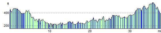
Elevation Profile