The Slaughters Walk
![]()
![]() This short walk between these two delightful Cotswolds villages is a favourite for visitors to the region. It follows the pretty River Eye from Lower Slaughter to Upper Slaughter. It's a special place with pretty little riverside cottages, stone footbridges, old watermills and picturesque village greens. Don't miss the wonderful 19th-century water mill in Lower Slaughter. It has an excellent museum, craft shop and riverside tea room.
This short walk between these two delightful Cotswolds villages is a favourite for visitors to the region. It follows the pretty River Eye from Lower Slaughter to Upper Slaughter. It's a special place with pretty little riverside cottages, stone footbridges, old watermills and picturesque village greens. Don't miss the wonderful 19th-century water mill in Lower Slaughter. It has an excellent museum, craft shop and riverside tea room.
This walk follows the
Warden's Way between the two villages so you could continue along this path if you would like to extend your walk. The Heart of England Way and the Macmillan Way also run past Lower Slaughter so you could pick up another path and head to the nearby Bourton on the Water. You can also follow the Macmillan Way north east to the town of Stow on the Wold.
Our 10 mile Circular Walk from Bourton through Naunton and The Slaughters will take you on a tour of the area using sections of the Windrush Way and Warden's Way long distance trails.
Postcode
GL54 2HX - Please note: Postcode may be approximate for some rural locationsThe Slaughters Ordnance Survey Map  - view and print off detailed OS map
The Slaughters Open Street Map  - view and print off detailed map
The Slaughters OS Map  - Mobile GPS OS Map with Location tracking
The Slaughters Open Street Map  - Mobile GPS Map with Location tracking
Explore the Area with Google Street View 
Pubs/Cafes
The Slaughters Country Inn is a fine choice for post walk refreshment. The inn serves fine food and has a lovely outdoor area next to the river. It's a great place to relax on a summer day. You can find them in Lower Slaughter at postcode GL54 2HS for your sat navs.
Dog Walking
The river trail is a fine one to do with your dog and the Slaughters Country Inn mentioned above is also very dog friendly.
Cycle Routes and Walking Routes Nearby
Photos
Lower Slaughter 1. The name of the village derives form the Old English term "slough" meaning "wet land". In the settlement there is a ford where the river widens in the village and several small stone footbridges join the two sides of the community.
Upper Slaughter 1. The village is notable as being one of the Thankful Villages, amongst the small number in England which lost no men in World War I. As it also lost no men in World War II, it is also known as a Doubly Thankful Village.
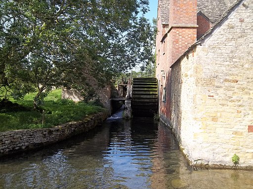
The old Watermill at Lower Slaughter. The mill dates back to the 1800s. It includes an undershot waterwheel and a chimney for additional steam power. The mill is built of red brick but most of the 16th and 17th century homes in the village use Cotswold limestone. They are generally adorned with mullioned windows and sometimes with other embellishments such as projecting gables.
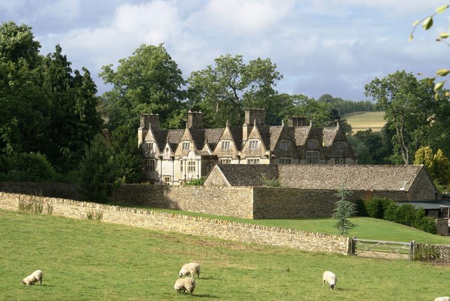
Upper Slaughter Manor. This is the one of the best public views of this fine old manor house. Somehow the building seems to blend easily into the landscape and it would be very easily missed while driving. Well worth a walk or at least getting out of the car to admire the architecture and the beautiful Cotswold stone.
The manor is recorded in the Domesday Book of 1086 while the Slaughter family acquired it in the late 12th century. The current building, on the site of an ancient building, was constructed over many years, starting in the Tudor era. Its crypt is estimated to be from the 14th century.


