Ogmore Valley Cycle Track
![]()
![]() Follow the Ogmore Valley Cycle Track from Aberkenfig to Nant-y-Moel on this traffic free cycle ride in Bridgend County.
Follow the Ogmore Valley Cycle Track from Aberkenfig to Nant-y-Moel on this traffic free cycle ride in Bridgend County.
The ride runs for just under 8 miles along a section of National Cycle Route 4 and a dismantled railway between the two villages.
The route starts in Aberkenfig near to Sarn train station. From here you can pick up the surfaced path and follow it north east along the Ogmore River towards Blackmill. You continue north, passing the Ogmore Forest, Ogmore Vale, Price Town and Wyndham before finishing at Nant-y-Moel.
Ogmore Valley Ordnance Survey Map  - view and print off detailed OS map
Ogmore Valley Open Street Map  - view and print off detailed map
Ogmore Valley OS Map  - Mobile GPS OS Map with Location tracking
Ogmore Valley Open Street Map  - Mobile GPS Map with Location tracking
Further Information and Other Local Ideas
The route links up with the Ogwr Ridgeway Walk at the confluence of the Ogwr Fach and Ogmore rivers at Blackmill. This waymarked trail provides wonderful views of the Ogwr Fach, Garw and Llynfi valleys. It finishes at Margam Country Park where there's an historic castle and some fine cycling and walking trails.
Cycle Routes and Walking Routes Nearby
Photos
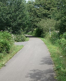
Cycle path in the Ogmore Valley. The path for cyclists and walkers which runs the length of the Ogmore Valley is seen here heading southwards from Ogmore Vale. This path either makes up or is a major part of the Ogmore Valley Community Route and Ogmore Valley Trail whereas the stretch of it between Nant-y-moel and Blackmill, on which the photograph was taken, comprises Route 883 of the National Cycle Network. The bollards seen help prevent motor vehicles from using the path and are found at other spots on the path where roads are met.


