Brookmans Park and Gobions Wood Walk
![]()
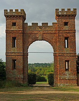
![]() This fine Hertfordshire based village is known for its BBC transmitters, excellent golf course and 18th century Folly Arch.
This fine Hertfordshire based village is known for its BBC transmitters, excellent golf course and 18th century Folly Arch.
For walkers there are some pleasant trails around the golf course and the Gobions Wood Nature Reserve.
The reserve is located just south of the village an includes footpaths taking you around a pond and peaceful ancient woodland. In the spring months there are lots of bluebells to see. Also look out for a variety of wildlife including blackcap, chiffchaff and buzzards.
The circular walk takes you through the reserve and then south to visit the historic folly arch which dates back to the 1700s.
The route then continues west to North Mymms and Water End where you can enjoy views of the local brook and the River Colne.
Postcode
AL9 7QW - Please note: Postcode may be approximate for some rural locationsBrookmans Park Ordnance Survey Map  - view and print off detailed OS map
Brookmans Park Open Street Map  - view and print off detailed map
Brookmans Park OS Map  - Mobile GPS OS Map with Location tracking
Brookmans Park Open Street Map  - Mobile GPS Map with Location tracking
Walks near Brookmans Park
- Hatfield Park - This Hertfordshire based town is a fine place for walkers with river trails along the River Lea, the woodland and parkland of Hatfield House and miles of easily accessible countryside trails to try.
- Lea Valley Walk - A super walk with a series of delightful waterside sections along the River Lea
- Northaw Great Wood - Explore 300 acres of woodland and parkland in this popular country park near Hatfield
- Broxbourne Woods - Follow the Broxbourne Woods Nature Trail on this splendid walk in Hertfordshire
- Hertfordshire Chain Walk - The Hertfordshire Chain Walk is a series of circular walks running through Hertfordshire
- Hertfordshire Way - Explore some of the finest countryside and prettiest towns and villages in this fascinating county
- Whitewebbs Park - This pretty country park in Enfield has some nice footpaths to follow around the parkland and woodland
- Potters Bar - This Hertfordshire based town is located close to Hatfield
Pubs/Cafes
Brookmans Pub is a fine place to enjoy some post exercise refreshment. They serve good quality dishes and have a lovely large garden area to relax in on warmer days.
You can find them at Bradmore Green with a postcode of AL9 7QW for your sat navs.
Photos
Water End Swallow Holes SSSI. Water End Swallow Holes are the only major sinkholes in chalk which are a permanent feature of the landscape. The site covers a group of more than 15 sinkholes where two streams drain from the London Clay and sink very close to the boundary of the outcrop of the chalk. This is the area where one of those streams, Mimmshall Brook, goes underground through a series of swallow holes. The whole site is an SSSI.
Water End, The Old Maypole. A date on the front wall of the public house implies that it was built circa 1520, although the style of the building suggests a later date. Perhaps there was an older building on the plot that was demolished, with the current public house replacing it. Nonetheless it is an old public house.


