Chesil Beach Walk
![]()
![]() This walk takes you along Chesil Beach to St Catherine's Chapel in Weymouth, Dorset. The walk starts from the Chesil Beach Centre car park at Portland Harbour. The centre has a welath of information about the area, wildlife exhibitions and a good cafe.
This walk takes you along Chesil Beach to St Catherine's Chapel in Weymouth, Dorset. The walk starts from the Chesil Beach Centre car park at Portland Harbour. The centre has a welath of information about the area, wildlife exhibitions and a good cafe.
The pebble beach runs for 18 miles with a series of beautiful lagoons on one side and the sea on the other. The Fleet lagoons are also a nature reserve so look out for a variety of coastal birds including Goldeneye and Manx shearwater.
This walk runs from the car park to Abbotsbury where you will find the delightful Abbotsbury Subtropical Gardens and St Catherine's Chapel which is dated from the 14th century. You can return along the beach or pick up the South West Coast Path at Abbotsbury and return on the other side of the lagoons.
You can also continue all the way along the beach to Burton Bradstock. This section of the beach passes West Bexington Nature Reserve and Burton Mere. The reserve consists of reedbed with grazing marsh and mixed coastal scrub. It is home to a variety of flora and fauna including Cetti's warbler, reed warbler, reed bunting, dormouse and water vole. As such it is another highlight of this wonderful stretch of Dorset coast.
At the end of the beach you will find the splendid Burton Bradstock Estate run by the National Trust.
Postcode
DT4 9XE - Please note: Postcode may be approximate for some rural locationsChesil Beach Ordnance Survey Map  - view and print off detailed OS map
Chesil Beach Open Street Map  - view and print off detailed map
Chesil Beach OS Map  - Mobile GPS OS Map with Location tracking
Chesil Beach Open Street Map  - Mobile GPS Map with Location tracking
Explore the Area with Google Street View 
Further Information and Other Local Ideas
Near the visitor centre at the Weymouth end of the beach you can pick up the Rodwell Trail. This popular shared cycling and walking trail will take you along a disused railway line to the ruins of Sandsfoot Castle and the lovely Radpole Lakes Nature Reserve.
On the route you will pass the worthy village of Langton Herring. The settlement includes a 17th century village pub and nice trails leading to the Moonfleet Manor Hotel. The coastal hotel is in a fine position with wonderful views to enjoy with your delicious afternoon tea.
Just to the south you can explore the Isle of Portland on our long circular walk. The route visits the famous Portland Bill lighthouse where you can enjoy a cream tea in the Lobster Pot restaurant. You'll also pass the Portland Quarry on the route. Here you will find the noteworthy Tout Quarry Sculpture Park, a popular attraction on the island. The site includes many interesting sculptures by artist's such as Anthony Gormley. There's also a nature reserve with lots of interesting wildflowers and butterflies.
For more walking ideas in the area see the Dorset Walks page.
Cycle Routes and Walking Routes Nearby
Photos
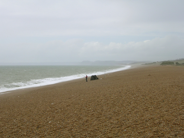
Northwestern end of Chesil beach, near Seawell Knap. A lone seafisherman braves the wind on this section of the beach. The beach shelves rapidly along the whole of the shingle bank. The huge cliff at the Golden Cap Estate can be seen through the spray in the distance.
Cogden Beach, Chesil Bank. View along the shore of Cogden Beach, itself a western stretch of the larger Chesil Bank. In the distance are the limestone cliffs at Burton Cliff, and lost in the spray is Golden Cap. The static caravans on the right are perched on a slope labelled as 'Cliff End' on the old maps, presumably because this is where the cliffs behind the bank end. From here to the Isle of Portland (in the opposite direction) there are no cliffs behind the bank - in fact for much of the Bank's length the lagoon known as "The Fleet" lurks behind the tomobolo.
Kite flying on the landward side of the Beach's northwestern end. This photo was taken from a point on the landward side of the shingle bank, sheltered from the prevailing SW wind. The wooden handrail follows a walkway up to the top of the bank from the car park.
The end of West Fleet, with anti-tank defences on the landward side of the beach. The marshes and WWII anti-tank defences on the shingle bank lie within the grid square. On the other side of the water is Abbotsbury Swannery and the hills on the left and right of the photo are Linton Hill and Chesters Hill respectively. The anti-tank defences on the seaward side of the beach have been removed by the action of the sea over the past 60 years.
Huts on the beach. These huts on the crest of the shingle bank probably have a military connection. View south east along the beach towards Portland.


