Devonport Leat
![]()
![]() This nice waterside walk visits Devonport Leat on Dartmoor. The route runs from near Burrator Reservoir to the aqueduct over the River Meavy just to the north. The leat was constructed in the 1790s to carry fresh drinking water from the high ground of Dartmoor to the expanding dockyards at Plymouth Dock. You can can now follow nice footpaths along the water in the Princetown area of Dartmoor.
This nice waterside walk visits Devonport Leat on Dartmoor. The route runs from near Burrator Reservoir to the aqueduct over the River Meavy just to the north. The leat was constructed in the 1790s to carry fresh drinking water from the high ground of Dartmoor to the expanding dockyards at Plymouth Dock. You can can now follow nice footpaths along the water in the Princetown area of Dartmoor.
Start the walk from the car park at Lowery Cross, just to the west of the reservoir. From here you head north east along the leat, passing through the woodland just north of Burrator. Eventually you will come to the River Meavy Aqueduct on Walkhampton Common. This walk returns on the same paths but you could extend your outing by following the path along the eastern side of Burrator Reservoir. Here you can also enjoy a climb up to Sheepstor and Gutter Tor for fine views over the area.
You can visit the other end of the leat around Wistman's Wood where it begins. There's a footpaths running along the least just to the west of the wood. You can follow it up to Beardown Tors to create a circular walk starting from the car park at Two Bridges.
Devonport Leat Ordnance Survey Map  - view and print off detailed OS map
Devonport Leat Open Street Map  - view and print off detailed map
Devonport Leat OS Map  - Mobile GPS OS Map with Location tracking
Devonport Leat Open Street Map  - Mobile GPS Map with Location tracking
Pubs/Cafes
For some post walk refreshments head south west of Burrator reservoir where you'll find the noteworthy Royal Oak in Meavy. The pub has fine credentials having been voted the 2019 Country Pub of the Year by Plymouth CAMRA. It's located in a delightful spot, next to Meavy Church and the pretty village green. There's a splendid outdoor seating area with a wide lawn where you can sit and enjoy a drink on fine days. The pub also has an interesting history having been a former 15th century Church house inn. It takes its name from the oak tree on the village green which is some 800 years old. This is one of the few remaining traditional Dartmoor inns with a flagstone floor, oak beams and a large open fireplace. Some of the seats are pews from adjacent church. You can find the pub less than half a mile south of the reservoir dam with a postcode of PL20 6PJ for your sat navs.


Pictured above, the Royal Oak pub and Meavy village green. A lovely place to relax after your walk on a summer day.
Further Information and Other Local Ideas
If you head a couple of miles north over Walkhampton Common you'll come to one of the hidden gems of the area at Foggintor Quarry. Here you'll find a tranquil lake surrounded by the atmospheric quarry ruins. There's also the option of continuing north west to visit King's Tor and Great Staple Tor where there are more great views to enjoy.
For more walking ideas in the area see the Dartmoor Walks page.
Cycle Routes and Walking Routes Nearby
Photos
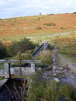
This shows the start of the Devoport leat on Dartmoor on the West Dart river on northern Dartmoor. A sluice to control the flow can be seen. This leat flowed by gravity to Devonport. It now feeds Burrator reservoir. The leat has been in use from around the start of the 18th century.
This shows the Devoport leat on Dartmoor close to Nun's Cross Farm looking up stream where the leat flows into the tunnel. This leat is taken from the West Dart & Cowsic rivers and flowed by gravity to Devonport. The length is over 34km and the leat was in use from around the start of the 18th century. The leat tunnel (Drivage Bottom) - was contructed C 1850.


