Dyfi Valley Way
![]()
![]() A walk through the beautiful Dyfi Valley taking you from Aberdovey (Aberdyfi) on the coast to Llanuwchllyn before returning along the river to Borth. There is a long wooded section through Dyfi Forest and waterside sections along the river to enjoy.
A walk through the beautiful Dyfi Valley taking you from Aberdovey (Aberdyfi) on the coast to Llanuwchllyn before returning along the river to Borth. There is a long wooded section through Dyfi Forest and waterside sections along the river to enjoy.
You'll also pass through the noteworthy town of Machynlleth as you skirt the edge of the Snowdonia National Park.
Around here there's some nice riverside trails through the Lllyfnant Valley.
Dyfi Valley Way Ordnance Survey Map  - view and print off detailed OS map
Dyfi Valley Way Open Street Map  - view and print off detailed map
Dyfi Valley Way OS Map  - Mobile GPS OS Map with Location tracking
Dyfi Valley Way Open Street Map  - Mobile GPS Map with Location tracking
Pubs/Cafes
The Red Lion in Machynlleth is a nice place to go for some refreshments on the route. The cosy pub has a good menu and is also dog friendly. Outside you can relax in the beer garden on warmer days. Inside there's interesting heavy rock memorabilia on the walls and a cosy atmosphere. You can find the pub at 11 Heol Maengwyn with a postcode of SY20 8AA for your sat navs.
In Dinas Mawddwy there's another Red Lion to visit. The pub serves good quality food and has a fine selection of ales. There's also a nice outdoor seating area with views of the surrounding area. You can find them at postcode SY20 9JA for your sat navs.
Further Information and Other Local Ideas
You can link up with the Borth to Ynyslas Coastal Path which will take you north along Borth Sands to visit Ynyslas and the Dyfi National Nature Reserve. There's some splendid high sand dunes to explore in the wildlife rich reserve. You can also enjoy lovely views over the Dyfi Estuary to Aberdovey on the opposite side.
Cycle Routes and Walking Routes Nearby
Photos

Aberdyfi moorings near the start of the route. The river Dyfi runs swiftly close inshore at high tide, its course marked by a line of foam. See how the boats tug at their moorings. Beyond them the Dfyi estuary and mountains of Ceredigion.

Pantperthog, Fforest Dyfi / Dyfi Forest, Pantperthog. Forest road with Tarren Gesail in the background.

Llanuwchllyn. The village of Llanuwchlyn near the southern end of Bala Lake. This photo is taken from the B4403.

Borth sea front. Borth is virtually a single road stretching some way down this four mile beach.

Eastward across Avon Dyfi valley at Cemmaes. Down in the bottom used to be the Mawddy branch of the Cambrian Railway (GWR) from Cemmaes Road to Dinas Mawddwy, which closed to passengers from 1/1/31 but was open for goods until 1/7/51. In the background are the Mynydd Cemmaes, rising to 1,296 ft.

View up the Dyfi valley near Dinas Mawddwy. Showing the mixed good and rough grazing, and commercial forestry, which is typical of the valley.

Looking north towards Pen-y-bont at Machynlleth.

Phone box near Brynmelyn. The field beyond is part of the Dyfi Valley Caravan and Camping site and is used mainly for touring, with chalets and static caravans on the other side of the road.
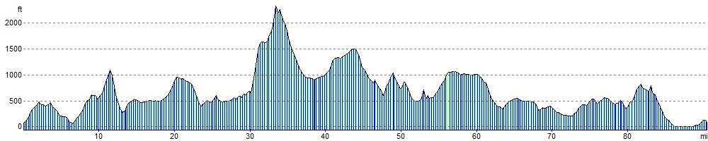
Elevation Profile