Elmley Castle Walks
![]()
![]() This little village is generally agreed to be one of the prettiest in Worcestershire. With delightul little cottages, a village pond and an old church dating from the 12th century, it's a typical picture postcard English village.
This little village is generally agreed to be one of the prettiest in Worcestershire. With delightul little cottages, a village pond and an old church dating from the 12th century, it's a typical picture postcard English village.
This circular walk from Elmley takes you to Bredon Hill and the Banbury Stone Tower. The walk starts in the village and follows footpaths south east to join with the Wychavon Way. This long distance trail will take you south west past the deer park and the site of the old castle after which the village is named. Continue past Fillder's Knap and you can pick up bridleways leading towards Bredon Hill. The hill summit stands at a height of 299 m (981 ft), providing wonderful views over the Cotswold Hills. It's also a historically significant area with the Iron Age Hill Fort of Kemerton Camp and a small stone tower known as Parsons Folly or Banbury Stone Tower.
The route rounds the hill, passing the neighbouring village of Overbury before descending past Comberton Wood and Windmill Hill to Elmley.
Elmley Castle Ordnance Survey Map  - view and print off detailed OS map
Elmley Castle Open Street Map  - view and print off detailed map
Elmley Castle OS Map  - Mobile GPS OS Map with Location tracking
Elmley Castle Open Street Map  - Mobile GPS Map with Location tracking
Pubs/Cafes
Back in the village head to Queen Elizabeth Inn for some post walk refreshments. It's a pub of some note, dating from the 16th century and named after the famous monarch who is reputed to have stayed there. According to local legend Elizabeth I was presented with a hat on her arrival in the village on the road from the nearby town of Pershore. It is thought the Queen and her entourage stayed for two nights as guests of William Savage. They have a lovely interior with timber beams, an original flagstone floor and a roaring log fire in the winter. Outside there's a patio and a small garden area for warmer days. They do high quality food and can be found at Main Street with a postcode of WR10 3HS for your sat navs.
Dog Walking
The hills, farmland and woods are ideal for dog walking. The Queen Elizabeth Inn mentioned above is also dog friendly.
Further Information and Other Local Ideas
Just a few miles north west you will find the worthy market town of Pershore. Here you can try the Pershore Walk and visit another local historical highlight at Pershore Abbey. The route also visits the peaceful woodland at Tiddesley Wood.
Also nearby is the impressive mansion and grounds at Croome Court, the historic Evesham Abbey Park River Walk and the lovely Evesham Country Park.
Near the River Severn there's the delightful village of Hanley Swan. The picturesque settlement includes a pretty village green, a pond, a 17th century pub and walking trails to neighbouring Hanley Castle where you can see the remains of the ancient fort.
The neighbouring village of Ashton Under Hill lies just to the south. The village makes a nice start point for a circular walk to Bredon Hill.
For more walking ideas in the area see the Cotswolds Walks and Worcestershire Walks pages.
Cycle Routes and Walking Routes Nearby
Photos
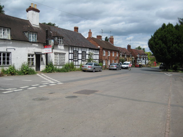
The picturesque main street in the centre of the village of Elmley Castle, the building on the left is the Queen's Head which is currently closed and for sale.
Site of Elmley Castle. The village takes its name from a castle which once stood on high ground above the present village. Viewed here from the northern slopes of Bredon Hill all that remains are earthworks which are clearly visible here. The castle was built by Robert le Despenser in the late 11th century and was for a time the principal seat of the Beauchamps. By the late 15th century the castle had been demolished.
Elmley Castle church is dedicated to St Mary. Parts of the nave with herring-bone masonry probably date from around 1100. The tower is later, dating from the 13th century. Inside the church there are monuments to the Savage family and also the First Earl of Coventry from Croome Court. The memorial was intended for Croome church but due to a family dispute it ended up in Elmley Castle church.


