Harting Down Circular Walk
![]()
![]() This large area of chalk downland on the South Downs is managed by the National Trust.
This large area of chalk downland on the South Downs is managed by the National Trust.
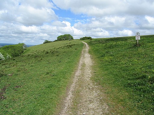
It's a wonderful place to go for a walk with splendid views over the downs and an abundance of flora and fauna. The area is covered with wild herbs, wild flowers and pyramidal orchids attracting butterflies such as the Duke of Burgundy fritillary and the Grizzled Skipper.
This circular walk starts in the National Trust car park and follows the South Downs Way to Beacon Hill - the highest point on Harting Down. The route then heads to Little Round Down where you will follow woodland trails through a large area of Yew woodland. Look out for wren, thrush and finch in this area. The final section climbs Harting Hill through more woodland to return you to the car park.
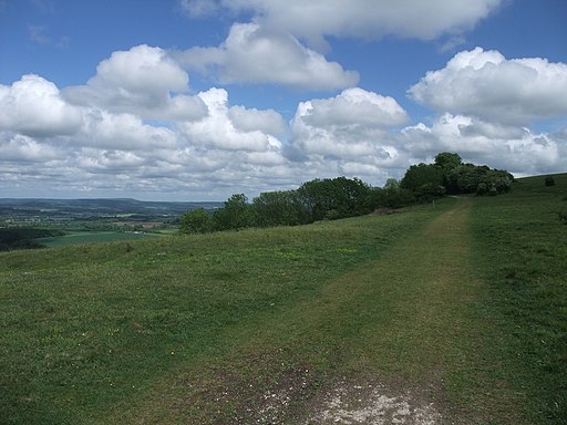
It's a splendid area with fabulous views across the Weald, the North Downs and towards the coast and the Isle of Wight. Look out for Fallow deer, Turtle Dove and Skylark on the downs.
The whole of this route is designed for walkers but you can mountain bike across Harting Down on the South Downs Way from the car park to Beacon Hill.
Postcode
GU31 5PN - Please note: Postcode may be approximate for some rural locationsHarting Down Ordnance Survey Map  - view and print off detailed OS map
Harting Down Open Street Map  - view and print off detailed map
*New* - Walks and Cycle Routes Near Me Map - Waymarked Routes and Mountain Bike Trails>>
Harting Down OS Map  - Mobile GPS OS Map with Location tracking
Harting Down Open Street Map  - Mobile GPS Map with Location tracking
Pubs/Cafes
Head north west into the village of South Harting and you can visit the White Hart for some post walk refreshment. The village pub has bags of character and a very good menu. Outside there's a delightful garden area where you can relax on a summer day. You can find them at a postcode of GU31 5QB for your sat navs.
Dog Walking
The woodland and downland are ideal for a dog walk. You'll probably meet other owners on a fine day. The White Hart pub mentioned above is also dog friendly.
Further Information and Other Local Ideas
In the village of South Harting you could pay a visit to the National Trust's Uppark. Here you'll find a fine 17th century Georgian House surrounded by lovely gardens with views of the English Channel. The author H.G Wells stayed in the house during the late 19th century. The class divisions he observed here inspired his socialist views which later manifested themselves in work such as 'The Time Machine'. You can find the house at postcode GU31 5QR.
A few miles to the west you can visit one of the area's major highlights at Queen Elizabeth Country Park. There's 2000 acres of attractive woodland and parkland with miles of cycling and walking trails to try. The pretty village of Buriton with its 18th century pub is also located near here.
Just to the west you can pick up the Clanfield Walk and visit Butser Ancient Farm and Windmill Hill. The farm is one of the area highlights and includes an archaeological open-air museum with reconstructions of Neolithic dwellings, Iron Age roundhouses, a Romano-British villa and an early Saxon house.
Cycle Routes and Walking Routes Nearby
Photos
South Harting from Harting Down. Looking north-west from the Down over the village of South Harting.
The area presents a classic example of chalk grassland enriched by centuries of grazing and natural processes. Walking along its well-trodden paths, you’ll encounter a mosaic of wildflowers that burst into life each spring. Delicate orchids, bright yellow horseshoe vetch, and clusters of rockrose lend vivid splashes of color against the pale, sun-bleached grasses. In the warmer months, the downland is alive with the buzz of insects, including a host of butterflies such as the chalkhill blue and the Adonis blue, while bees and other pollinators dart from flower to flower, their activity a vital part of this delicate ecosystem.
Seat with a view. The open, rolling landscape also provides shelter for an array of wildlife. Birds such as skylarks and wheatears can often be seen flitting above the fields, their calls echoing across the expansive down, while ground-nesting species take advantage of the open, sheltered conditions. Small mammals like rabbits and field voles make their homes among the low vegetation, and on sunny days, you might catch a glimpse of reptiles such as common lizards and adders basking on warm stones. The interplay of light and shadow on the undulating terrain creates a constantly changing backdrop, adding to the charm of the walk.
On Harting Downs. Beyond its rich natural tapestry, Harting Down offers more than just a feast for the senses. The area is steeped in history and tradition; ancient field boundaries, dry stone walls, and remnants of old farming practices speak to a long agricultural heritage. The landscape itself, shaped by both human influence and natural forces, offers expansive views over the South Downs, inviting walkers to pause and appreciate the serene beauty and timeless quality of this iconic chalk downland. Whether you are a dedicated nature enthusiast or simply seeking a peaceful escape, a stroll along Harting Down provides an enriching experience where natural wonder and historical depth coexist in perfect harmony.


