Uppark Walks
![]()
![]() This walk visits the National Trust's Uppark House in South Harting West Sussex.
This walk visits the National Trust's Uppark House in South Harting West Sussex.
The 17th-century house is surrounded by pleasant grounds with woodland and gardens to explore. The author H.G Wells stayed in the house during the late 19th century. The class divisions he observed here inspired his socialist views which later manifested themselves in work such as 'The Time Machine'.
The house is located just a mile west of Harting Down where you can extend your outing on a number of good cycling and walking trails. You can also pick up the South Downs Way National Trail and climb to a fine viewpoint in this area. Queen Elizabeth Country Park, Iping Common and Stedham Common are other good local options.
Postcode
GU31 5QR - Please note: Postcode may be approximate for some rural locationsUppark Ordnance Survey Map  - view and print off detailed OS map
Uppark Open Street Map  - view and print off detailed map
Uppark OS Map  - Mobile GPS OS Map with Location tracking
Uppark Open Street Map  - Mobile GPS Map with Location tracking
Pubs/Cafes
Head into the village of South Harting and you can visit the White Hart for some post walk refreshment. The village pub has bags of character and a very good menu. Outside there's a delightful garden area where you can relax on a summer day. You can find them at a postcode of GU31 5QB for your sat navs.
Dog Walking
The estate grounds and the adjacent Harting Down are great for dog walking. There's water bowls, dog bins and dog-friendly walks so its a popular place.
Further Information and Other Local Ideas
Just to the west you can pick up the Clanfield Walk and visit Butser Ancient Farm and Windmill Hill. The farm is one of the area highlights and includes an archaeological open-air museum with reconstructions of Neolithic dwellings, Iron Age roundhouses, a Romano-British villa and an early Saxon house.
Cycle Routes and Walking Routes Nearby
Photos
Uppark house and grounds, 1987. Two years later in 1989 the house was to suffer a terrible fire. It has since been restored by the National Trust.
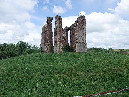
The Vandalian Tower Ruins on Tower Hill. Ruins and viewpoint east of the house. It stands in the heart of the West Sussex countryside, yet its roots lie in America. The historical folly dates back to the 18th century. It was constructed to commemorate the British colony of Vandalia, a colony that eventually disappeared as the American colonies evolved. The Vandalian Tower is situated on the summit of Tower Hill and serves as a fascinating relic of the past. This folly, with its unique design and historical significance, adds a distinctive charm to the landscape.
Today, the Vandalian Tower is owned by the descendants of the Fetherstonhaugh family, who also purchased the neighboring estate of Uppark. The Tower was recognised for its historical importance and was listed as a scheduled monument in 1976, ensuring its preservation for future generations to appreciate.


