Haworth Moor Circular Walk
![]()
![]() This circular walk explores Haworth Moor in the popular Bronte country. The walk visits some of the highlights of the area including Penistone Hill Country Park, Leeshaw Reservoir and the Bronte Waterfall. The route involves a fairly challenging hill climb so a good level of fitness is required.
This circular walk explores Haworth Moor in the popular Bronte country. The walk visits some of the highlights of the area including Penistone Hill Country Park, Leeshaw Reservoir and the Bronte Waterfall. The route involves a fairly challenging hill climb so a good level of fitness is required.
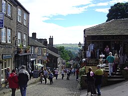
The walk starts from the village of Haworth where you can follow footpaths south west to Penistone Hill Country Park. There's a great viewpoint here with fine views over the moor.
You continue west along a section of the Bronte Way.
The waymarked footpath takes you past the Lower Laithe Reservoir to the Bronte Waterfall. The picturesque spot was a favourite of the Bronte sisters, who would often spend time contemplating at the falls. You could continue about a mile west from here to visit Top Withens. The ruined farmhouse is said to have been the inspiration for Wuthering Heights.
This route continues south west to Harbour Hill and Oxenhope Stoop Hill, which is the high point on the walk. The route then descends to Bond Clough Hill and the pretty Leeshaw Reservoir.
The final section runs past Drop Farm before heading through the country park and returning to Haworth.
Haworth Moor Circular Walk Ordnance Survey Map  - view and print off detailed OS map
Haworth Moor Circular Walk Open Street Map  - view and print off detailed map
Haworth Moor Circular Walk OS Map  - Mobile GPS OS Map with Location tracking
Haworth Moor Circular Walk Open Street Map  - Mobile GPS Map with Location tracking
Pubs/Cafes
Haworth Old Hall is a good option for refreshments after your walk. The historic 16th century inn has a charming interior with beautiful open log fires. The Tudor inn is one of the oldest buildings in the village dating back to 1621. The hall has a fascinating history with two elaborate tunnels buried beneath it. Once used as an escape route, one of the tunnels connects directly to Haworth Parish Church. During times of religious persecution, the owners would use the tunnels beneath the house to offer the nonconformist people of Haworth a safe passage of escape from the forces of the Church of England.
The hall does very good food and if the weather is fine you can sit out in the large beer garden. You can find the inn Sun Street at postcode BD22 8BP for your sat navs.
Dog Walking
The expansive moor makes for a great dog walk but it's probably best to keep them on leads in some areas where there is livestock. There are some fairly steep climbs too so you and your pet need to be in pretty good shape. Haworth Old Hall mentioned above is also dog friendly.
Further Information and Other Local Ideas
If you head east of the moor you can explore the Worth Valley on the Keighley Worth Way. This circular walk visits Haworth and Oxenhope with its two pretty reservoirs.
Cycle Routes and Walking Routes Nearby
Photos
Pennine Way crossing Haworth Moor. As the Pennine Way crests Haworth Moor, the Worth Valley opens up to reveal the ruins of Top Withens House in the middle distance.
Looking south east from Oxenhope Stoop Hill. The stone marks the boundary between Bradford and Calderdale Metropolitan districts. Historically this was the boundary of Halifax parish, one of the largest in England
Wall along Deep Nitch. This wall runs for a kilometre along Deep Nitch from Oxenhope Stoop Hill to Stairs Lane. The ancient parish (and modern Metropolitan District) boundary runs parallel, approximately 100m south west. The area between is shown on maps as The Waste. The wall provides a useful navigational feature in otherwise featureless terrain.


