Highdown Hill and Highdown Gardens
![]()
![]() This walk visits Highdown Gardens before climbing Highdown Hill in the South Downs. The walk begins at the car park at Highdown Gardens. Both the gardens and parking are free, though you are free to make a donation if you wish. You can then follow a series of footpaths through the park with its beautiful collection of rare plants and trees. The chalk gardens are situated on Downland countryside with wonderful views towards the sea. Highlights include two pretty ponds with fish, toads and newts, a Himalayan Birch Bark Cherry Avenue, a Rose Garden and a Herb Garden.
This walk visits Highdown Gardens before climbing Highdown Hill in the South Downs. The walk begins at the car park at Highdown Gardens. Both the gardens and parking are free, though you are free to make a donation if you wish. You can then follow a series of footpaths through the park with its beautiful collection of rare plants and trees. The chalk gardens are situated on Downland countryside with wonderful views towards the sea. Highlights include two pretty ponds with fish, toads and newts, a Himalayan Birch Bark Cherry Avenue, a Rose Garden and a Herb Garden.
After touring the gardens you can then continue your walk to Highdown Hill. The hill stands at 81 metres (266 ft) and is a popular spot for walkers. From the summit there are wonderful views of the coast including the Seven Sisters and the Isle of Wight.
Highdown Hill and Highdown Gardens are located in between Littlehampton and Worthing.
To continue your walking in the area head to Littlehampton where you can pick up a nice riverside footpath along the River Arun. You can follow this all the way to Arundel on the Arundel to Littlehampton River Walk. Here there's the opportunity to explore the fascinating Arundel Castle and Arundel Park.
Postcode
BN12 6FB - Please note: Postcode may be approximate for some rural locationsPlease click here for more information
Highdown Hill and Highdown Gardens Ordnance Survey Map  - view and print off detailed OS map
Highdown Hill and Highdown Gardens Open Street Map  - view and print off detailed map
Highdown Hill and Highdown Gardens OS Map  - Mobile GPS OS Map with Location tracking
Highdown Hill and Highdown Gardens Open Street Map  - Mobile GPS Map with Location tracking
Explore the Area with Google Street View 
Further Information and Other Local Ideas
The circular Worthing Walk can be picked up a few miles east of the park. It visits the Iron Age fort at Cissbury Ring before heading across the South Downs to the 11th century ruins of Bramber Castle.
For more walking ideas in the area see the Sussex Walks and South Downs Walks pages.
Cycle Routes and Walking Routes Nearby
Photos
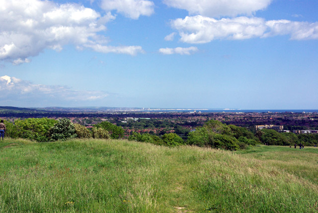
View east from Highdown Hill. In the foreground is the rampart of the ancient fort at the top of this isolated chalk hill. The distant view is across Worthing and Brighton to the chalk cliffs extending from the east of Brighton past Newhaven to Seaford Head and finally to the Belle Tout cliff near Beachy Head. Some claim Beachy Head itself is visible from here, it probably is, but from the land side, not the cliff itself.
Footpath, Highdown Hill in the summer of 2008. Viewed from the western ramparts of the former Iron Age fort and looking out onto the coastal plain below. If you strain your eyes and look between the bushes on the centre right you can just make out the outline of the Isle of Wight. Highdown Hill was originally settled in the Bronze Age and was used during the Iron Age and by the Romans who built a bath house on the western side of the slope. The Saxons also used the fort for both defence and as a cemetery. The footpath follows an ancient east-west route.
Footpath to Highdown Hill. From the bridleway just south of Ecclesden Mill. The line of bushes at the end of the wheat field mark the boundary with the National Trust owned hill.
View south from the hill. The sea is in the distance, across the Sussex coastal plain. The hill is an isolated chalk outcrop, quarried of old in the foreground. Most of the coastal plain here is residential, but in the mid-distance on the right glasshouses and orchards are to be seen, and on the left an equestrian establishment.


