Hungerford Walks - Near and Around
![]()
![]() This market town in Berkshire is a fine place for walkers with easy river and canalside walking to enjoy. It's also close to the North Wessex Downs, an Area of Oustanding Natural Beauty with numerous options for walkers.
This market town in Berkshire is a fine place for walkers with easy river and canalside walking to enjoy. It's also close to the North Wessex Downs, an Area of Oustanding Natural Beauty with numerous options for walkers.
This circular walk from the town explores Hungerford Common before picking up a pleasant section of the Kennet and Avon Canal Walk.
The walk starts from the car park on Hungerford Common and picks up footpaths heading south east across the common to Templeton Stud. The expansive common is a great place for walks in the town with miles of footpaths to explore.
You continue north east along a country lane towards Kintbury where you can link up with the canal. Follow the towpath west and it will take you back towards Hungerford with views of the River Kennet which runs alongside the canal. There's also lots of boats and pretty locks to see in this picturesque area.
Postcode
RG17 0DY - Please note: Postcode may be approximate for some rural locationsHungerford Ordnance Survey Map  - view and print off detailed OS map
Hungerford Open Street Map  - view and print off detailed map
*New* - Walks and Cycle Routes Near Me Map - Waymarked Routes and Mountain Bike Trails>>
Hungerford OS Map  - Mobile GPS OS Map with Location tracking
Hungerford Open Street Map  - Mobile GPS Map with Location tracking
Walks near Hungerford
- Newbury - The delightful Berkshire town of Newbury is a great place for waterside walks along the rivers, canal and lakes you can find in the area.
This short, easy stroll takes you along the Kennet and Avon Canal to the nearby Thatcham Discovery Centre - Newbury to Kintbury and Hungerford Canal Walk - Enjoy an easy stroll along the Kennet and Avon Canal from Newbury to Hungerford via the lovely village of Kintbury
- Snelsmore Common Country Park - This circular walk takes you around the peaceful Snelsmore Common Country Park in Newbury and on into the surrounding countryside along public footpaths
- Greenham Common - Explore the Greenham and Cookham Commons on this circular walk near Newbury
- Ashford Hill Nature Reserve - Explore the old water meadows and woodland in this pretty nature reserve near Newbury
- Highclere Castle - This walk uses public footpaths to explore the extensive parkland surrounding this Stately home near Newbury
- Beacon Hill Newbury - This circular walk climbs to the Beacon Hill viewpoint in the grounds of Highclere Castle in Hampshire.
- Three Downs Link - This is a walking and cycling path following bridleways through Hampshire, Berkshire, Wiltshire and Oxfordshire
- Donnington Castle - Enjoy a stroll around this historic castle before visiting the nearby Snelsmore Common on this circular walk in Newbury
- Tadley - This Hampshire based town is located near to some large areas of woodland and the attractive scenery of the North Downs
- Pamber Forest - This large forest in Tadley covers nearly 500 acres
- Silchester - This walk follows the waymarked Silchester trail around the Hampshire village
- Aldermaston - This Berkshire based village has some nice river and canalside trails to try.
- Bowdown Woods - This nature reserve sits on the northern edge of Greenham Common.
- Chilton Foliat - This little Wiltshire village near Hungerford is a lovely place for a stroll
Pubs/Cafes
The John O Gaunt is a great place to enjoy some post exercise rest and refreshment. The historic inn dates back to the 16th century and has been awarded West Berkshire Pub of the year. Inside there's a charming old interior with many original features. Outside there's an award winning garden with heated tiki tents if it's a bit chilly. They have a fine menu and can be found at 21 Bridge Street, with postcode RG17 0EG for your sat navs.
Dog Walking
The common is ideal for dog walking so you'll probably see other owners on a fine day. The John O Gaunt pub mentioned above is also dog friendly.
Further Information and Other Local Ideas
The little village of Chilton Foliat lies less than two miles to the north west of the town. It's a lovely place for a stroll with several pretty thatched cottages, wildlife rich marshland and nice views of the River Kennet which runs through the settlement. Near here you can also visit Littlecote House, another of the area's highlights. The house dates from the mid 16th century and is surrounded by beautiful parkland and gardens. There's also a wonderful ancient Roman mosaic and the opportunity to enjoy afternoon tea at the historic house which is now run as an hotel.
Photos
Hungerford High Street. Looking south from the bridge carrying the A338 over the Kennet and Avon Canal. The next bridge is the railway line, with the town hall clock tower behind. The alley to the right leads down to the canal towpath.
Hungerford Common. This is a view of the wide lane that runs south east across the grid square and is situated in the north east section of the grid square. The picture was taken somewhat south east of the parking, looking southeast.
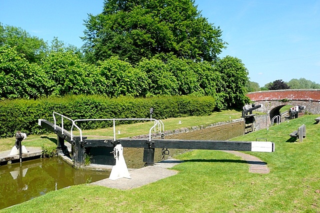
Dun Mill Lock Lock 75, with a fall of 5 feet 8 inches. This lock is regularly used by the canal trip boat Rose of Hungerford.
River and canal. On the left is the River Kennet. On the right, a few feet higher, is the Kennet and Avon Canal. The canal follows the Dun valley from Crofton to near here where the River Dun joins the River Kennet. At times the River Kennet is higher than the canal (not here) and various weirs allow the canal to be fed by the river and to get rid of any excess. Here the towpath runs between the two.
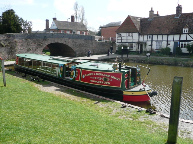
"Rose of Hungerford" at the Wharf. Rose is a trip boat operated by volunteers of the Kennet and Avon Canal Trust. Here she is waiting for Sunday afternoon passengers. Public trips on Saturdays, Sundays and Wednesdays, and you may even meet yours truly as I am one of the volunteer captains. The bridge behind is Hungerford town bridge, carrying the A338. The houses to the right are contemporary with the canal, first built in about 1796.
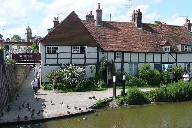
Hungerford wharf. The town bridge carrying the A338 is to the left, leading into High Street stretching up to the railway bridge and the town hall with the clock in the distance. These cottages are contemporary with the age of the canal, 1796. Today it is a popular place for feeding the ducks, and the ducks know that.


