Ingatestone Walks
![]()
![]() This pretty Essex based village has some nice country trails to try. There's also a noteworthy old hall and views of the River Wid which runs to the east of the settlement. The village includes some fine old timber framed buildings and was listed as one of the best places to live in the UK in 2020 by the Sunday Times.
This pretty Essex based village has some nice country trails to try. There's also a noteworthy old hall and views of the River Wid which runs to the east of the settlement. The village includes some fine old timber framed buildings and was listed as one of the best places to live in the UK in 2020 by the Sunday Times.
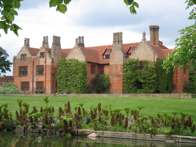
This circular walk from the village heads south to explore the countryside around Ingatestone Hall and Buttsbury. The Grade I listed hall dates from the 16th century and was built by Sir William Petre. Today the manor house is open to the public on certain days between Easter and September. It includes some lovely grounds and formal gardens which are ideal for an easy afternoon stroll.
Postcode
CM4 0AT - Please note: Postcode may be approximate for some rural locationsIngatestone Ordnance Survey Map  - view and print off detailed OS map
Ingatestone Open Street Map  - view and print off detailed map
*New* - Walks and Cycle Routes Near Me Map - Waymarked Routes and Mountain Bike Trails>>
Ingatestone OS Map  - Mobile GPS OS Map with Location tracking
Ingatestone Open Street Map  - Mobile GPS Map with Location tracking
Walks near Ingatestone
- Billericay - This Essex based town has some nice country walking trails, a popular local wood and a nearby reservoir to enjoy.
- Norsey Woods - These lovely woods near Billericay have some good waymarked footpaths to try
- Hanningfield Reservoir - This large body of water near Billericay has some nice woodland walking trails at its southern end
- St Peters Way - Travel from Chipping Ongar to the 7th century St Peter's Chapel on St Peter's Flat on this walk through Essex
- Thorndon Country Park - This large country park is located near Brentwood in Essex and contains a number of fine woodland trails, ideal for walking or cycling
- Upminster - This East London town is located in a nice spot in the London Borough of Havering
- Hornchurch Country Park - Enjoy a walk or cycle through this large country park in Havering in the Ingrebourne Valley
- South Woodham Ferrers - This Essex based town has some nice waterside footpaths along the local creek and river to try
- Battlesbridge - This Essex based village has some nice local trails along the River Crouch and a well known antiques centre housed in a picturesque old mill.
- Wickford - This Essex based commuter town is located on the tidal River Crouch, within the Borough of Basildon
- Marsh Farm Country Park - This country park in South Woodham Ferrers has miles of splendid waterside walking trails to enjoy
- Belhus Woods Country Park - Enjoy the pretty lakes and peaceful woodland trails in this country park near Ockendon and Dagenham.
Pubs/Cafes
Head to the Bell Inn for some post walk refreshment. The historic pub is housed in a 500 year old coaching inn on the High Street in the village centre. They have a good menu and a lovely garden to relax in on warmer days. You can find them at 55 High Street with a postcode of CM4 0AT for your sat navs.
There's also the Star Inn which dates back to the 15th century.
Dog Walking
The country trails are nice to do with your dog and the Bell pub mentioned above is also dog friendly.
Further Information and Other Local Ideas
Head south east and you could visit the neighbouring town of Billericay where you'll find some pleasant walks around Norsey Woods.
To the south west there's Brentwood where you can visit Weald Country Park and Thorndon Country Park.
For more walking ideas in the area see the Essex Walks page.
Photos
Ingatestone Hall. The south face of the Elizabethan Ingatestone Hall from across the Stewpond. Queen Elizabeth I spent several nights at the hall on her Royal Progress of 1561.


