Llanfairfechan to Conwy Circular Walk
![]()
![]() This seaside resort in Conwy County has some lovely coastal trails, riverside paths, lovely beaches and some local challenging hill climbs to try.
This seaside resort in Conwy County has some lovely coastal trails, riverside paths, lovely beaches and some local challenging hill climbs to try.
This circular walk from the town uses sections of the Wales Coast Path and the North Wales Path to visit Conwy Mountain before climbing to the hills of the Sychnant Pass.
The walk starts in the town centre where you can pick up the Wales Coast Path and follow the waymarked trail towards the neighbouring town of Penmaenmawr. You continue along the nice beach here to Conwy Morfa, rounding the golf course before coming to the pretty marina. There's nice views here over the Conwy River estuary.
In the town you pick up the North Wales Path and follow it west up to Conwy Mountain. There's wonderful views here to the coast and surrounding hills of Snowdonia. Follow the elevated path south and it will take you to Capelulo, Maen Esgob, Waen Gyrach, Cefn Coch and Moelfre. The route then descends to the Llanfairfechan River which you can follow back into the town.
Llanfairfechan to Conwy Circular Walk Ordnance Survey Map  - view and print off detailed OS map
Llanfairfechan to Conwy Circular Walk Open Street Map  - view and print off detailed map
*New* - Walks and Cycle Routes Near Me Map - Waymarked Routes and Mountain Bike Trails>>
Llanfairfechan to Conwy Circular Walk OS Map  - Mobile GPS OS Map with Location tracking
Llanfairfechan to Conwy Circular Walk Open Street Map  - Mobile GPS Map with Location tracking
Pubs/Cafes
Back in the town the Virginia Inn is a fine choice for post walk refreshments. There a good selection of ales and beer garden to relax in on fine days. You can find the pub in the town centre at postcode LL33 0TH for your sat navs.
You could also head to the Beach Pavillion Cafe on the sea front. They serve a good range of meals and snacks which you can enjoy with a sea view from the outdoor seating area. You can find them on the Promenade at a postcode of LL33 0BY.
Dog Walking
The beach and coast path is a nice one to do with your dog. The inland sections through the hills will only suit fit dogs with some experience of this sort of terrain. The Virginia Inn mentioned above is dog friendly.
Further Information and Other Local Ideas
Just to the south west of the Conwy Mountain you will pass close to the Jubilee Path. The elevated path was constructed in 1887 to commemorate the Golden Jubilee of Queen Victoria. It offers fine views to the sea and has a small car park for access. There's also the option of climbing to Foel Lus in this area.
The climb to Foel Fras starts from the town. You can follow footpaths south to Drum and then onto the summit which stands at a height of 942 m (3,091 ft) making it one of the Welsh 3000s (mountains over 3000ft high). From the high pint there are wonderful views over Carneddau and the rest of Snowdonia.
A few miles south west of the town there's one of the walking highlights of the area at the beautiful Aber Falls in Abergwyngregyn. The 120 ft high falls are part of the stunning scenery of the Coedydd National Nature Reserve with its wonderful woodland and mountain scenery.
For more walking ideas in the area see the Snowdonia Walks page.
Cycle Routes and Walking Routes Nearby
Photos
Llanfairfechan promenade. Menai Straits in the distance, and Anglesey beyond.
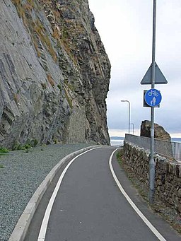
Cycle track round Penmaenbach Point. The headland at Penmaenbach forms a formidable barrier to communication along the north Wales coast. In the days of horse and cart, carriages had to be dismantled to carry them round the headland! Nowadays, things are a little bit easier as the main A55 North Wales Expressway is carried through the headlands in tunnels. Unlike the Pen-y-Clip tunnels a short way to the west, a good cycle and pedestrian path runs alongside the road round the outside of this headland, approximately along the line of the old (pre-tunnel) road.
Dogs posing at the Summit Cairn on Moelfre. A hill located to the south east of the town. The cairn which is shown on the map is a disappointment. The bald summit which gives the hill its name is also almost featureless. View of Great Orme in the background.


