Lunesdale Walk
33.6 miles (54 km)
![]()
![]() This figure of eight walk takes you on a tour of the beautiful scenery around Carnforth.
This figure of eight walk takes you on a tour of the beautiful scenery around Carnforth.
The trail takes in a series of waterways including the Lancaster Canal and the Rivers Lune, Hindburn, Wenning and Roeburn while also passing through several pretty towns and villages. Starting in Carnforth you will pass Swarthdale, Melling, Roeburndale, Hornby, Arkholme and Capernwray. You can also enjoy views of Morecambe Bay with the Cumbrian Mountains making a spectacular backdrop. Part of the walk also passes through the stunning Forest of Bowland AONB with its fabulous landscapes, woodland, hills and variety of wildlife.
Please click here for more information
Lunesdale Walk Ordnance Survey Map  - view and print off detailed OS map
Lunesdale Walk Open Street Map  - view and print off detailed map
Lunesdale Walk OS Map  - Mobile GPS OS Map with Location tracking
Lunesdale Walk Open Street Map  - Mobile GPS Map with Location tracking
Cycle Routes and Walking Routes Nearby
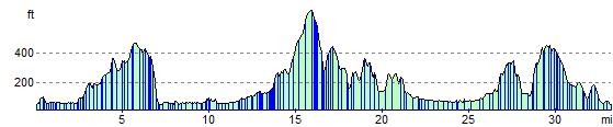
Elevation Profile