Malin Head Walk
![]() This walk visits Malin Head, the most northerly point of mainland Ireland. The headland is located on the scenic Inishowen peninsula in County Donegal.
This walk visits Malin Head, the most northerly point of mainland Ireland. The headland is located on the scenic Inishowen peninsula in County Donegal.
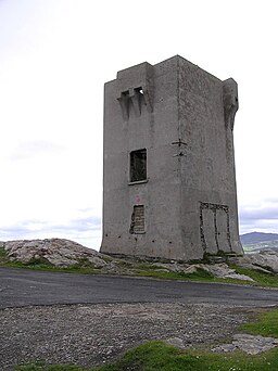
There is a parking area where you can start your circular walk around the headland. Here you can enjoy fine views over the Atlantic to Inishtrahull Island to the north. Other features of the area include a Tower dating from 1805 and a weather station which features in the BBC Shipping Forecast.
The area also includes Ballyhillion beach, a unique raised beach system of international scientific importance.
Scenes from the film 'Star Wars: The Last Jedi' were filmed in Malin Head. The Millennium Falcon could be seen perched on the cliffs with storm troopers roaming the hills. Actor Mark Hamill even visited Farren’s Bar (See below) for some refreshments.
To continue your walking in the area head south to explore the Mamore Gap. There's a good cycling and walking trail taking you through the Gap with great views of the surrounding hills and the Inishowen Peninsula.
Malin Head Open Street Map  - view and print off detailed map
Ireland Walking Map - View All the Routes in the Country>>
Malin Head Open Street Map  - Mobile GPS Map with Location tracking
Pubs/Cafes
Farren’s Bar can be found just to the south east of the headland. It is notable as Ireland's most Northerly pub. The friendly pub serves fine food and an excellent pint of Guinness. They even have some Star Wars memorabilia and murals. You can find them at Slievebawn, Malin Head, Co. Donegal, F93 FX56. The pub is dog friendly.
Further Information and Other Local Ideas
To the south there's the lovely Inch Island in Lough Swilly. Here you can try the loop walk at the Inch Wildfowl Reserve and look out for a wide variety of wildlife on the water.
Head south east and you could pick up the Moville Shore Walk and visit Ballybrack Beach. This fine coastal walk takes you from Moville to Greencastle with glorious views across Lough Foyle to enjoy on the way.
The Dunree Head Walk will take you past the picturesque lighthouse and Dunree Fort, a historic military site. The Buncrana Coastal Walk can also be picked up in this area. There is another old fort and fine views over Lough Swilly here.
Cycle Routes and Walking Routes Nearby
Photos
Marconi Wireless Telegraph Station, Malin Head, Co. Donegal, 1990. Taken by photographer, Arthur Spears, who noted: The Tower is known as a Lloyds Watching Station, built in 1805. The Marconi Station (where the men are standing in the original photograph) is now in ruins. The third structure on the extreme left of the photograph is an Irish Army 'Look Out Post'. LOPs were built during World War II during the 'Emergency' .


