Osmington White Horse Walk
![]()
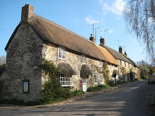
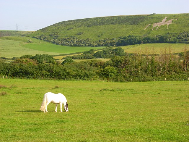
![]() Climb to the Osmington White Horse and enjoy wonderful views along the Jurassic Coast on this circular walk in Dorset. You start the walk from the interesting village of Osmington, near Weymouth. The village includes a church dating from the 12th century and picturesque thatched dwellings dating back to the 16th century. You then pick up the South Dorset Ridgeway and the South West Coast Path to take you up to Osmington Hill. The distinctive figure dates from the early 19th century and represents King George III riding his horse. After taking in the views you descend to the village of Sutton Poyntz. It's a lovely little village with thatched cottages, a stream with a nice footpath and a mill pond. It's a great place to stop for refreshments before the final leg back to Osmington. This takes you along public footpaths past White Horse Farm before returning you to the village.
Climb to the Osmington White Horse and enjoy wonderful views along the Jurassic Coast on this circular walk in Dorset. You start the walk from the interesting village of Osmington, near Weymouth. The village includes a church dating from the 12th century and picturesque thatched dwellings dating back to the 16th century. You then pick up the South Dorset Ridgeway and the South West Coast Path to take you up to Osmington Hill. The distinctive figure dates from the early 19th century and represents King George III riding his horse. After taking in the views you descend to the village of Sutton Poyntz. It's a lovely little village with thatched cottages, a stream with a nice footpath and a mill pond. It's a great place to stop for refreshments before the final leg back to Osmington. This takes you along public footpaths past White Horse Farm before returning you to the village.
If you'd like to continue your walk you could head down to the lovely Osmington Mills and enjoy views of Osmington Bay. Continue east along the coast path and you will pass the site of the medieval village of Ringstead before coming to Ringstead Bay. If you would like to view the white horse without the walk you can visit the new Osmington White Horse viewpoint. It can be found on the A353 heading towards Osmington from Weymouth. It has information boards and a great view of the white horse.
Osmington White Horse Ordnance Survey Map  - view and print off detailed OS map
Osmington White Horse Open Street Map  - view and print off detailed map
Osmington White Horse OS Map  - Mobile GPS OS Map with Location tracking
Osmington White Horse Open Street Map  - Mobile GPS Map with Location tracking
Pubs/Cafes
In Osmington Mills you'll find the noteworthy Smuggler's Inn. Situated on the cliff tops of the South West Coast Path, just outside the village of Osmington, the Smugglers Inn is a traditional English pub with stunning views overlooking the Isle of Portland. The pub also has an interesting history having been the headquarters of the French smuggler Pierre Latour and one of the main landing places for smuggled goods in the 17th century. Notably the Inn was originally built in the 13th century, with its own brewery at the rear. There's a lovely large garden area which is perfect for relaxing in when the weather is fine. You can fine the pub right on the coast at a postcode of DT3 6HF for your sat navs.
Further Information and Other Local Ideas
Head west along the South West Coast Path and you will soon come to Lodmoor Country Park. The popular park includes an outdoor gym, go karts, model railway, circular tree trail and pitch and putt golf course. There's also a nature reserve with good footpaths and lots of wildlife to see on the lakes and pools.
Cycle Routes and Walking Routes Nearby
Photos
Bridleway near Osmington. The track (here followed by an inland alternative route of the SW Coast Path) drops from Whitehorse Hill to the River Jordan valley and then rises again towards the village. Hedges, many at right angles to the slopes, form a bocage landscape in contrast to the surrounding open hills.
Ascent of White Horse Hill. The bridleway from Osmington, shared by the inland route of the coastal path, climbs gently until it reaches this gate, with grazing land either side. Then, as it reaches the corner, the gradient steepens for the final climb towards the crest of the hill.
On White Horse Hill. This is one of those hills that is more photographed from afar, because of the white horse carved in its southern face. On top, is an excellent bridleway, part of the inland route of the coastal path, almost a contradiction until explained as the alternative route of the South West Coast Path running along the chalk scarp a mile or so inland and offering excellent coastal views. Here, looking east, the path crosses grazing land before descending gently towards Osmington.


