Ticknall Tramway Tunnel Walk
![]()
![]() This walk explores the old Ticknall to Ashby tramway in Calke Abbey, Derbyshire. The industrial tramway connected the brickyards, lime quarries and lime yards of Ticknall to the Ashby Canal. The horse drawn system operated from 1802 to 1913. Today part of the route makes for a nice leisurely walk or cycle.
This walk explores the old Ticknall to Ashby tramway in Calke Abbey, Derbyshire. The industrial tramway connected the brickyards, lime quarries and lime yards of Ticknall to the Ashby Canal. The horse drawn system operated from 1802 to 1913. Today part of the route makes for a nice leisurely walk or cycle.
Start the walk in Ticknall and then head south west from the town along the trail and you will soon come to the tunnel. You'll then pass some farms and woodland before coming to Southwood. Here you turn north east to follow other trails through Calke Park. The site has an interesting history having been an Augustinian priory from the 12th century until its dissolution by Henry VIII. There's some splendid architecture and lovely gardens to enjoy here. The final section of the walk takes you through some woodland before returning to the village.
There's good options nearby for extending your walk if you have time. Staunton Harold Reservoir and Foremark Reservoir are located either side of the trail. There are some nice waterside trails and woodland footpaths to explore here.
Ticknall Tramway Tunnel Walk Ordnance Survey Map  - view and print off detailed OS map
Ticknall Tramway Tunnel Walk Open Street Map  - view and print off detailed map
Ticknall Tramway Tunnel Walk OS Map  - Mobile GPS OS Map with Location tracking
Ticknall Tramway Tunnel Walk Open Street Map  - Mobile GPS Map with Location tracking
Pubs/Cafes
There's a National Trust cafe at Staunton Harold Reservoir where you can buy light lunches, tasty snacks and refreshing drinks. The cafe is located at Calke Road, Windmill Hill with a postcode of DE73 8DN.
In Ticknall itslef there are a few good refreshment options. For example there's the excellent Chequers Inn. The friendly pub has a cosy fire indoors and a good sized garden area to sit out in. You can find it in the village at 27 High St with a postcode of DE73 7JH for your sat navs.
Further Information and Other Local Ideas
Ticknall is located close to the town of Melbourne where there are some lovely walks at the southern end of the town. Our Melbourne Hall and Pool Walk visits the historic hall and the pretty pool. You can pick up the two mile trail near the north eastern end of Staunton Harold Reservoir. Just over a mile north of the town you can also join with the Trent and Mersey Canal near Weston-on-Trent. There's some nice easy cycling and walking along the towpath here.
The National Forest Way passes through the area. The long distance trail takes you to several of the highlights of the National Forest area.
Cycle Routes and Walking Routes Nearby
Photos
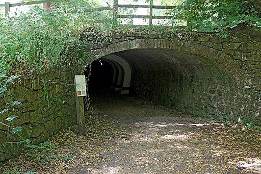
Ticknall Tramway tunnel: The tramway was built in 1802 by Benjamin Outram to connect the local limeworks to the Ashby Canal. The 140 yard long tunnel was constructed simply so as not to conflict with the driveway to Calke Abbey, and is of cut-and-cover build. This is the eastern tunnel mouth. The strengthening arches visible inside are under the driveway itself so as to be able to cater for modern vehicles. The tunnel is a Scheduled Monument. It has been restored to form part of an extended cycle and pedestrian route along the tramway.
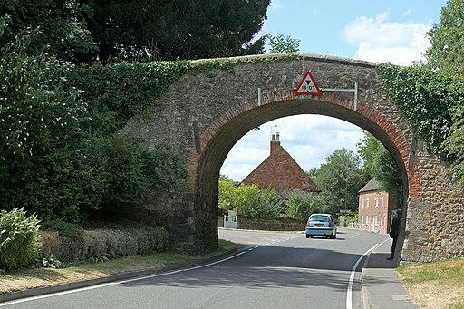
Ticknall Tramway Arch. Built as part of Benjamin Outram's 1802 horse tramway connecting the local limeworks to the Ashby Canal. Listed Grade II, the listing describes it as built in 1794 although most sources date the tramway to c.1802.
Tramway bridge at Ticknall. This bridge once supported the a horse-drawn tramway, which ran 12 miles from the Ticknall limeyards and brickyards to the Ashby Canal at Willesley Basin. The tramway was built by Benjamin Outram, opened in 1802 and closed in 1915. The driveway leading off to the right is the entrance to Calke Park.


