Ver-Colne Valley Walk
![]()
![]() Follow the rivers Ver and Colne on this waterside walk through Hertfordshire.
Follow the rivers Ver and Colne on this waterside walk through Hertfordshire.
The walk starts at Redbourn and follows the River Ver to the historic town of St Albans with its impressive cathedral and the delightful Verulamium Park.
This section of the walk passes along the lovely lake in the park which also has a fascinating history stretching back 2000 years. It is named after the Roman city of Verulamium on which it now stands. Near here you will also find the Watercress Wildlife Site, a pretty riverside nature reserve. The site has a wide variety of wildlife, including water rails, kingfishers, little grebes and muntjac deer.
The path then continues south, joining the river Colne for the final stretch into Watford.
This walk has much to enjoy including, lakes, weirs and numerous species of river dwelling wildlife.
Ver-Colne Valley Walk Ordnance Survey Map  - view and print off detailed OS map
Ver-Colne Valley Walk Open Street Map  - view and print off detailed map
Ver-Colne Valley Walk OS Map  - Mobile GPS OS Map with Location tracking
Ver-Colne Valley Walk Open Street Map  - Mobile GPS Map with Location tracking
Pubs/Cafes
In the pretty village of Redbourn there's a couple of good options. The Hollybush dates from the 16th century and does a fine Sunday roast which you can enjoy in the nice garden area to the rear. You can find them at postcode AL3 7DU.
There's also the Cricketer's which is in a lovely spot overlooking Redbourn Common. They also serve high quality food and can be found at postcode AL3 7ND. Both pubs are also dog friendly if you have your canine friend with you.
Further Information and Other Local Ideas
From the northern side of Verulamium Park you can pick up the Gorhambury Estate Walk. Follow the trail north west past the Roman theatre and it will take you across the scenic estate and past the 18th century Gorhambury House. The estate also includes the historicially significant Old Gorhambury House. The 16th century house is now a ruin run by English Heritage. It's well worth a small diversion from the route.
On the northern outskirts of St Albans there's miles of good cycling and walking trails to be found around the Heartwood Forest near Sandridge.
Cycle Routes and Walking Routes Nearby
Photos
Redbournbury watermill. This mill was rebuilt completely after a fire, and now once more mills wheat to make flour, although the lack of water in the river Ver means that it now uses electricity rather than waterpower
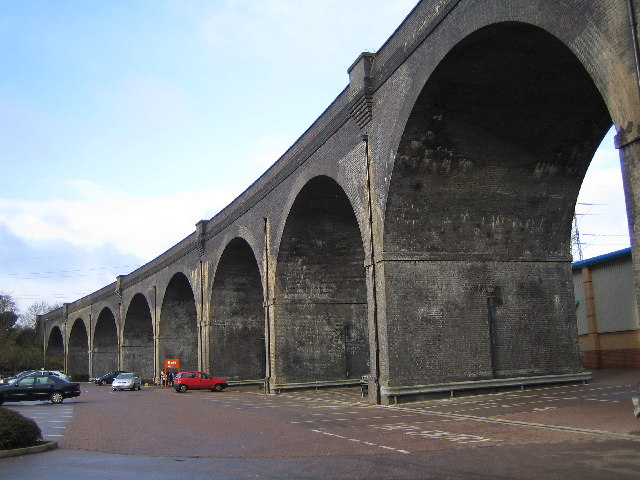
Watford: River Colne railway viaduct. The viaduct was originally built, and is still in use, to carry local trains from Bushey to Watford High Street stations over the valley of the River Colne. The diverted loop of Watford's Lower High Street now passes through two of the arches on the north side of the river while the remaining arches straddle the car park of the unsurprisingly named Arches Retail Park.
Elevation Profile


