Walsall Arboretum
![]()
![]() This delightful arboretum has a series of good footpaths to follow around the site. There's 80 acres (32 ha) to explore with lakes, ponds and a waterside stroll along the pretty Hoor Brook. Look out for an extraordinary 10000 species of tree and shrub as you make your way through the area. The park also has an interesting history as one of the oldest parks in the borough, being originally opened in 1874.
This delightful arboretum has a series of good footpaths to follow around the site. There's 80 acres (32 ha) to explore with lakes, ponds and a waterside stroll along the pretty Hoor Brook. Look out for an extraordinary 10000 species of tree and shrub as you make your way through the area. The park also has an interesting history as one of the oldest parks in the borough, being originally opened in 1874.
There's a car park at the south eastern end of the park off Broadway North. From here you can pick up the surfaced paths through the park to Hatherton Lake at the other end.
The park hosts a popular parkrun every Saturday morning at 9:00 am.
It's easy to extend your walk by visiting the nearby Park Lime Pits. The park incldues ponds, woodland, streams and over 300 species of plants. Here you can also pick up the Beacon Way long distance trail and enjoy a waterside walk along the Wyrley and Essington Canal.
Just to the north is the pretty Mill Lane Nature Reserve with ponds and the Ford Brook running through it.
Just to the west you will find the Walsall Canal where you can enjoy a walk or cycle along the towpath.
Postcode
WS4 2BU - Please note: Postcode may be approximate for some rural locationsWalsall Arboretum Ordnance Survey Map  - view and print off detailed OS map
Walsall Arboretum Open Street Map  - view and print off detailed map
Walsall Arboretum OS Map  - Mobile GPS OS Map with Location tracking
Walsall Arboretum Open Street Map  - Mobile GPS Map with Location tracking
Explore the Area with Google Street View 
Pubs/Cafes
There's an on site cafe selling a good range of refreshments.
Dog Walking
The park is a popular place for dog walkers so you will probably see other owners on your visit.
Further Information and Other Local Ideas
One nice idea in the Walsall area is to pick up the Beacon Way and enjoy a climb to Barr Beacon. The beacon is one of the highlights of the Black Country and a high point of the Birmingham city area. On the summit there is a distinctive domed war memorial and excellent views over the city and beyond.
For more walking ideas in the area see the West Midlands Walks page.
Cycle Routes and Walking Routes Nearby
Photos
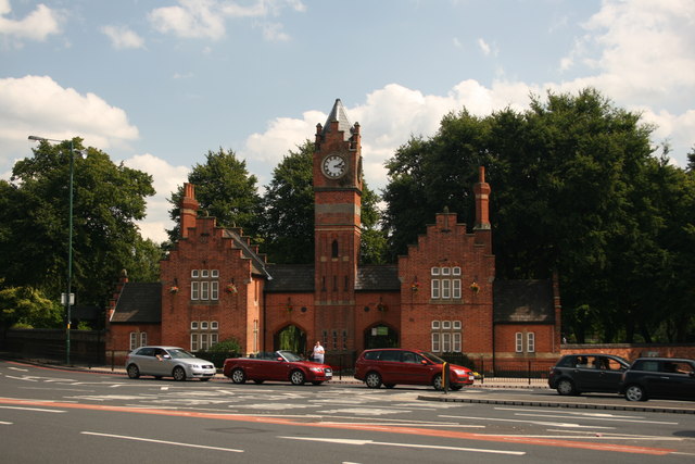
Entrance to Walsall Arboretum. The entrance used to look out to a large traffic roundabout which always had good floral displays. Sadly, since the advent of the new ring road all that can be seen is traffic stuck at the new traffic lights.
The Arboretum was established in 1871 based on flooded former limepits. By 1873 the lodge gatehouses, bandstand and brick boundary wall had been built and the park was officially opened in 1874 - admission 2d.


