Worsley Woods
![]()
![]() This circular walk around Worsley uses a series of public footpaths to explore these pretty woods in Salford. There's shady trails, streams, a lake, sculptures and a wild flower trail to enjoy.
This circular walk around Worsley uses a series of public footpaths to explore these pretty woods in Salford. There's shady trails, streams, a lake, sculptures and a wild flower trail to enjoy.
You can start the walk from the car park off Greenleach Lane at the northern end of the woods. From here you can pick up the trails heading south along the Kempnough Brook to the Old Warke Dam. Then follow paths along the lake to the Worsley Canal Basin before picking up other footpaths to take you back to the car park.
The Bridgewater Canal runs past the southern and western end of the woods so you can easily pick up the towpath to extend your walk. Heading west will take you toward Astley while heading south will take you toward Patricroft and Trafford Park. See our Worsley Canal Walk for more details.
Just to the north east you will find Clifton Country Park abd Prestwich Forest Park where there are more good walking and cycling trails to try.
Postcode
M28 2GD - Please note: Postcode may be approximate for some rural locationsWorsley Woods Ordnance Survey Map  - view and print off detailed OS map
Worsley Woods Open Street Map  - view and print off detailed map
Worsley Woods OS Map  - Mobile GPS OS Map with Location tracking
Worsley Woods Open Street Map  - Mobile GPS Map with Location tracking
Pubs/Cafes
The Delph Restaurant and Bar is located just to the south of the woods. The pub overlooks the Worsley Delph, an historic site which became the start of the first industrial canal in the country. They have a good food and drinks menu including a fine Sunday Roast. You can find them at Worsley Rd, M28 2NL.
Dog Walking
The woods are ideal for a dog walk with miles of trails to explore. It's a popular place so expect to see other owners on your visit.
Cycle Routes and Walking Routes Nearby
Photos
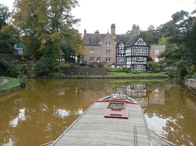
Worsley junction. To the right is the branch up into the Delph for the mine workings which were the main reason for the building of the Bridgewater Canal. The line to Leigh continues to the left. The red colour of the water is due to the minerals leaching out of the old mine workings. Straight ahead is Worsley Packet House. The helmsman of the narrowboat has to make a hard left turn and hope that there is nothing coming the other way through the bridge.
Worsley Delph with nesting swans. An iconic industrial archaeology site, now pleasantly sylvan. Worsley Delph is the start of 46 miles of tunnels that lead to a network of underground mines. Nestling up against the openings to these tunnels are the outlines of mining boats that would have gone in and out, first empty and then full of the coal they collected. They give a hint at what it would have looked like over a quarter of a century ago as day to day life was carried out in the Delph.


