Wysis Way
![]()
![]() The Wysis Way runs for 55 miles from Monmouth in Wales to Kemble, in Gloucestershire. The way links the Offa's Dyke Path and Thames Path national trails.
The Wysis Way runs for 55 miles from Monmouth in Wales to Kemble, in Gloucestershire. The way links the Offa's Dyke Path and Thames Path national trails.
Starting from the Wye Bridge in Monmouth the Wysis Way heads eastwards up to The Kymin and on into the Forest of Dean. Continuing east the trail goes through Hillersland before continuing through the Forest, passing through Nailsbridge, Harrow Hill and Mitcheldean on its way to the top of May Hill where there are fabulous views of the River Severn. From May Hill, it continues eastward through Glasshouse, Taynton, Tibberton and the edge of Highnam before reaching Gloucester. At Gloucester, the trail heads south east to Robinswood Hill, before continuing southeasterly through Painswick, Bisley and Oakridge Lynch before reaching its end in Kemble, where it meets the Thames Path.
Wysis Way Ordnance Survey Map  - view and print off detailed OS map
Wysis Way Open Street Map  - view and print off detailed map
*New* - Walks and Cycle Routes Near Me Map - Waymarked Routes and Mountain Bike Trails>>
Wysis Way OS Map  - Mobile GPS OS Map with Location tracking
Wysis Way Open Street Map  - Mobile GPS Map with Location tracking
Pubs/Cafes
Stop off in Slad at The Woolpack Inn for some refreshments on the walk. It's over 300 years old and retains much of that old world charm. Indoors there's a cosy interior with lots of interesting old pictures and photos on the wall. The pub was the old haunt of author Laurie Lee and after you have finished your meal you can head across the road to the church where he is buried. They do excellent food and also have an outdoor area for warmer days. You can find the historic inn on the Slad Road at a postcode of GL6 7QA for your sat navs. The pub is also dog friendly if you have your canine friend with you.
Further Information and Other Local Ideas
At the end of the walk in Kemble you could visit the Source of the River Thames. There is a monument with an inscription to mark the source of the river at this significant spot.
Cycle Routes and Walking Routes Nearby
Photos

The path cuts through the northern fringe of a conifer stand on the upland plateau.

The Way nears its eastern conclusion at the source of the Thames, about half a kilometre away. This stile and gate are less than 100 metres south of Coatesfield Bridge on the Thames and Severn Canal.

Battle of Barber's Bridge Monument. The monument commemorates the battle of Barber's Bridge which took place in 1643. The B4215 passes this spot, as does the former Gloucester and Hereford Canal, later superseded by the railway, both now long defunct. Today the Wysis Way, a long distance footpath connecting Offa's Dyke Path and the Thames Valley Path follows the course of the old railway at this point.

The Wysis Way and Three Choirs Way. A shared section of track with a birthday party evident near Over Farm, west of Gloucester.

Tree on Near Hearkening Rock. The roots of a tree find their way into mossy crevices on the summit, near its northern end. The track below is the Wysis Way.
.jpg)
Wysis Way marker in Forest of Dean near Symonds Yat

Harryhill Plantation. The break in the trees marks the route of power lines. This is the position where the Wysis and Gloucestershire Ways leave the A4136.

Track near Over Farm. This track situated to the north of Over Farm is the route of two long distance paths, The Wysis Way and the Three Choirs Way. The former connects the River Wye and Offa's Dyke Path at Monmouth with the source of the River Thames in the Cotswolds, the latter is a circular path link the Three Choirs cathedrals of Gloucester, Hereford and Worcester.
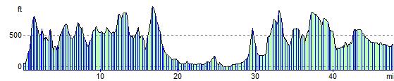
Elevation Profile