Arbor Low
![]()
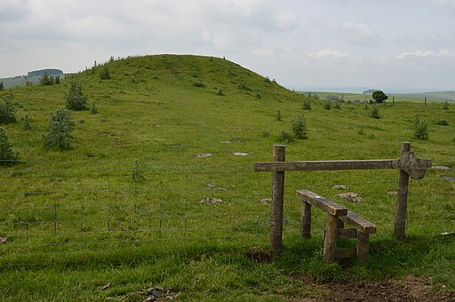
![]() Visit this Neolithic henge monument and enjoy some lovely moorland scenery on this fascinating circular walk in the Peak District. The site is located a few miles west of Youlgreave. You can park at Upper Oldhams Farm just off Long Rake. Walk through the farm (there is a £1 charge per person) and then climb towards Arbor Low. The limestone circle sits in an elevated position with super views over the White Peak area of the Peak District. The henge is one of the most well preserved in Britain with 50 large limestone slabs and fragments. It's an atmospheric place, thought to date back to 2500BC to 1500 BC. After you have explored the stone circle you can head south west to Gib Hill where you will find an ancient burial mound.
Visit this Neolithic henge monument and enjoy some lovely moorland scenery on this fascinating circular walk in the Peak District. The site is located a few miles west of Youlgreave. You can park at Upper Oldhams Farm just off Long Rake. Walk through the farm (there is a £1 charge per person) and then climb towards Arbor Low. The limestone circle sits in an elevated position with super views over the White Peak area of the Peak District. The henge is one of the most well preserved in Britain with 50 large limestone slabs and fragments. It's an atmospheric place, thought to date back to 2500BC to 1500 BC. After you have explored the stone circle you can head south west to Gib Hill where you will find an ancient burial mound.
The High Peak Trail and the Midshires Way both pass close to the site at Parsley Hay.
You could pick up these long distance footpaths to extend your walking in the area. Heading north west will take you to Pomeroy while heading south takes you towards Hartington and the Biggin Dale Nature Reserve.
Just over a mile to the north you'll find the beautiful Lathkill Dale. This is a great place to extend your walking in the White Peak. There are wonderful limestone cliffs and the rushing waters of the River Lathkill to enjoy.
Postcode
DE45 1JS - Please note: Postcode may be approximate for some rural locationsArbor Low Ordnance Survey Map  - view and print off detailed OS map
Arbor Low Open Street Map  - view and print off detailed map
Arbor Low OS Map  - Mobile GPS OS Map with Location tracking
Arbor Low Open Street Map  - Mobile GPS Map with Location tracking
Pubs/Cafes
The historic Bull's Head in Monyash is a fine place for some post walk refreshments. The main draw here is an excellent beer garden which is surrounded by green fields with mature trees, barns and limestone walls. If the weather is good it's the perfect spot to relax and enjoy a meal. Inside there's a cosy interior with a log fire and an inscription which dates all the way back to 1619. The pub is also dog friendly and provides water bowls scattered around the garden. You can find the inn on Church Street with a postcode of DE45 1JH for your sat navs.
Further Information and Other Local Ideas
You can reach the site from the nearby village of Monyash by following Derby Lane south from the village. It's about a 2 mile walk so should take around 40 minutes.
Cycle Routes and Walking Routes Nearby
Photos
Gib Hill Barrow. It is thought to be a Neolithic oval barrow with an Early Bronze Age round barrow superimposed at one end. It is located some 300 metres south-west of Arbor Low henge.


