Hutchison Way - Wellington to Newport via Telford Walk
![]()
![]() This walk was created by Telford & Wrekin council as a millennium project and named after late former Chief Executive of the council David Hutchison. It runs from Wellington to Newport via Telford and passes through woodland, country parks and some lovely Shropshire countryside.
This walk was created by Telford & Wrekin council as a millennium project and named after late former Chief Executive of the council David Hutchison. It runs from Wellington to Newport via Telford and passes through woodland, country parks and some lovely Shropshire countryside.
Walk highlights include splendid views of The Wrekin in the Shropshire Hills Area of Outstanding Natural Beauty. This prominent landmark forms a beautiful backdrop for much of the walk.
You will also visit The Ercalll with its small hill, quarries and wood. The area is full of flora and fauna and is regarded as an internationally important geological site.
At Donnington wood you will pass through Granville Country Park.
Here you will find a variety of plantlife including Orchids, ox-eye daisy and cowslips.
Hutchison Way Ordnance Survey Map  - view and print off detailed OS map
Hutchison Way Open Street Map  - view and print off detailed map
*New* - Walks and Cycle Routes Near Me Map - Waymarked Routes and Mountain Bike Trails>>
Hutchison Way OS Map  - Mobile GPS OS Map with Location tracking
Hutchison Way Open Street Map  - Mobile GPS Map with Location tracking
Cycle Routes and Walking Routes Nearby
Photos

The restored Old Forge Basin in Granville Country Park, once part of the Donnington Wood Canal

Ercall Hill, in Shropshire, England.
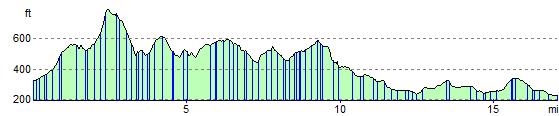
Elevation Profile
GPS Files
GPX File
Hutchison Way.gpx (On Desktop:Right Click>Save As. On Ipad/Iphone:Click and hold>Download Linked File)NB GPS file for this route only details route start - route is waymarked from there in