Ober Water Walk
![]()
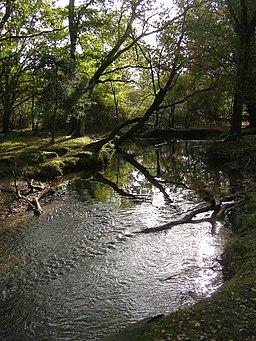
![]() This nice, easy walk takes you around the pretty Ober Water in the New Forest. The circular walk starts from the Whitefield Moor car park and follows good tracks through the Aldridge Hill woodland and the Ober Valley. It's a really delightful spot with the tranquil stream surrounded by shady woodland glades. It's a great place for a picnic and a paddle on a summer's day!
This nice, easy walk takes you around the pretty Ober Water in the New Forest. The circular walk starts from the Whitefield Moor car park and follows good tracks through the Aldridge Hill woodland and the Ober Valley. It's a really delightful spot with the tranquil stream surrounded by shady woodland glades. It's a great place for a picnic and a paddle on a summer's day!
Ober Water is located just over a mile west of Brockenhurst.
If you'd like to extend your walk then the Blackwater Arboretum Trail is located just over a mile to the north. The village of Burley is also nearby. There's nice trails to try here in the Old and New Inclosures.
Postcode
SO42 7QD - Please note: Postcode may be approximate for some rural locationsOber Water Ordnance Survey Map  - view and print off detailed OS map
Ober Water Open Street Map  - view and print off detailed map
*New* - Walks and Cycle Routes Near Me Map - Waymarked Routes and Mountain Bike Trails>>
Ober Water OS Map  - Mobile GPS OS Map with Location tracking
Ober Water Open Street Map  - Mobile GPS Map with Location tracking
Further Information and Other Local Ideas
The Puttles Bridge Walk walk starts from the nearby car park and heads along the water before exploring the Aldridgehill Inclosure and paying a visit to Rhinefield House. This old manor house is now a hotel surrounded by beautiful grounds which include ornamental ponds, gardens and a fountain. You could stop here for some post walk refreshments and enjoy a stroll around the grounds.
South of the stream you'll find Whitefield Moor. The moor is a nice open area of grassland with ponies and horses grazing. There are some waymarked trails to be found here.
For more walking ideas in the area see the New Forest Walks page.
Cycle Routes and Walking Routes Nearby
Photos
Pig and piglets in woodland alongside Ober Water. A strip of riverine woodland follows the course of the stream, and at its edges it can be a bit scrubby - as shown in this photo. These pigs have come into the woodland from the neighbouring heath in search of food and are rooting in the soft soil and eating acorns from the oaks. Each year the pigs (which belong to New Forest commoners) are allowed onto the open Forest for 60 days, known as "pannage" season, to eat acorns which would otherwise poison the ponies.
Footbridge over the stream at Ferny Knap. Looking across the Water, with the trees of the Ferny Knap Inclosure in the distance. The footbridge and causeway leading up to it look like relatively recent constructions. The Forestry Commission maintains the network of bridges and causeways that make possible public access to the heath and bog in the Forest.
Footbridge over the Water south of the Clumber Inclosure. This area of heathland and bog would be inaccessible to walkers without footbridges like this one, constructed by Forestry Commission engineers. The path carried by this bridge comes down from Holm Hill and then rises towards the Clumber Inclosure, which can be seen in the distance.


