Tan Hill Way - Pewsey Downs, Milk Hill, Morgan's Hill Walk
![]()
![]() This walk takes you through the beautiful Marlborough Downs in Wiltshire. You will pass Pewsey Downs, Milk Hill, Tan Hill and Morgan's Hill with fabulous views of the surrounding countryside for the duration of the walk.
This walk takes you through the beautiful Marlborough Downs in Wiltshire. You will pass Pewsey Downs, Milk Hill, Tan Hill and Morgan's Hill with fabulous views of the surrounding countryside for the duration of the walk.
The start point of the walk is the car park at Clench Common with the finish at Morgan's Hill which is also a nature reserve of the Wiltshire Wildlife Trust.
The route passes close to the Milk Hill summit which is the highest point of Wiltshire. You can take a small detour from the path to reach the summit. Here you can enjoy extensive views to the Mendip Hills, the Cotswolds and in clear weather as far as the Black Mountains in Wales. In this area you will also pass the noteworthy Alton Barnes White Horse hill figure.
The walk also passes along a section of the Wansdyke Path which offers an alternative route for exploring the area.
Tan Hill Way Ordnance Survey Map  - view and print off detailed OS map
Tan Hill Way Open Street Map  - view and print off detailed map
*New* - Walks and Cycle Routes Near Me Map - Waymarked Routes and Mountain Bike Trails>>
Tan Hill Way OS Map  - Mobile GPS OS Map with Location tracking
Tan Hill Way Open Street Map  - Mobile GPS Map with Location tracking
Pubs/Cafes
At the Alton Barnes White Horse head south from the hill to the canal at Honeystreet for some refreshments. Here you'll find the idyllic Barge Inn. This historic pub is located right next to the canal and includes an outdoor seating area wih glorious views across the canal to the Marlborough Downs and the Alton Barnes White Horse. It's the ideal place to relax in and watch the world go by on warm summer days. The pub also has an interesting history having originally been built in 1810 to service the newly built Kennet and Avon canal, it was the equivalent of a modern day motorway service station. It then burnt down in the 1850s only to be rebuilt in record time so it now stands as it did then. The pub can be found just to the west of Pewsey in Honeystreet, near Alton Barnes. Postcode for you sat navs is SN9 5PS.
Further Information and Other Local Ideas
The Pewsey Walk will take you along the Kennet and Avon Canal Walk and then into the countryside of the Vale of Pewsey and onto Pewsey Downs where there are splendid views from the high points. It also uses part of the trail around Knap Hill before visiting the village of Wootton Rivers which is just south of the trail.
For more walking ideas in the area see the Wiltshire Walks and the North Wessex Downs Walks pages.
Cycle Routes and Walking Routes Nearby
Photos

Tan Hill from Rybury Hillfort. In the foreground is the flat path which runs around prehistoric Rybury. The path is flanked in most areas by earthworks. The fort is an Iron Age camp built upon a Neolithic Hillfort and within the ring it is extremely hummocky and has numerous burrows. The path in the distance leads up to Tan Hill and the Wansdyke runs E-W over the skyline.

The Wansdyke on Tan Hill 1. Looking east along the Wansdyke towards Milk Hill, this section has the path following the higher rampart along the southern side of the deep ditch. The ditch here is some 30 feet deep and was intended to stop Saxon invasion from the north in the 6-7th Century.

The Wansdyke on Tan Hill 2. This is taken looking along the bottom of the ditch with earthen ramparts very evident on both sides. Sheep enjoy the shelter from the wind within the confines of the ditch. The hill summit is the second highest point of the North Wessex Downs AONB hill range.

Downland West of Tan Hill. Views are extensive from Tan Hill, ranging from Cheesefoot Head near Winchester to the south-east to, in clear weather, the Black Mountains in Wales to the north-west.

Bridleway to Martinsell Hill, near Clench Common

View from Huish Hill on the Pewsey Downs

Cyclists, Morgan's Hill. The cyclists are heading west along a byway followed by the Wessex Ridgeway and the White Horse Trail, and which follows the line of the Roman road from Bath to London.

Oare Hill
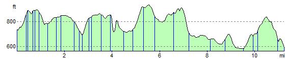
Elevation Profile