Bristol to Gloucester
52.8 miles (85 km)
![]()
![]() This ride starts on the River Avon in Bristol and takes you along the River Severn to Gloucester.
This ride starts on the River Avon in Bristol and takes you along the River Severn to Gloucester.
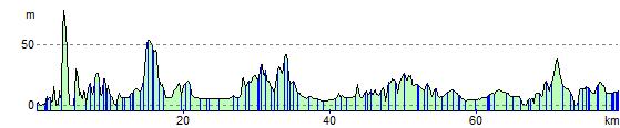
The route follows the National Cycle Route 41 for most of the way and is largely flat so expect a nice relaxing scenic ride.
Route highlights include the impressive Clifton Suspension Bridge, the 12th century Berkeley Castle, the Gloucester and Sharpness Canal and the Slimbridge Wetland Centre where there's a fantastic array of wildlife to see.
Bristol to Gloucester Ordnance Survey Map  - view and print off detailed OS map
Bristol to Gloucester Open Street Map  - view and print off detailed map
Bristol to Gloucester OS Map  - Mobile GPS OS Map with Location tracking
Bristol to Gloucester Open Street Map  - Mobile GPS Map with Location tracking
Cycle Routes and Walking Routes Nearby
Photos

Clifton Suspension Bridge

The Wetlands at Slimbridge

Gloucester and Sharpness canal path
Elevation Profile