Circular Walk around Gloucester
![]()
![]() This famous cathedral city is located in a great spot for walkers close to the edge of both the Cotswolds and the Malvern Hills Walks. In the city itself there's nice waterside trails along the canal and river which skirt the city's eastern edge. There's also a local country park with woodland trails and an excellent viewpoint over the city.
This famous cathedral city is located in a great spot for walkers close to the edge of both the Cotswolds and the Malvern Hills Walks. In the city itself there's nice waterside trails along the canal and river which skirt the city's eastern edge. There's also a local country park with woodland trails and an excellent viewpoint over the city.
This circular walk takes you to some of the highlights of the city, visiting the cathedral, the docks, the Gloucester and Sharpness Canal and the River Severn.
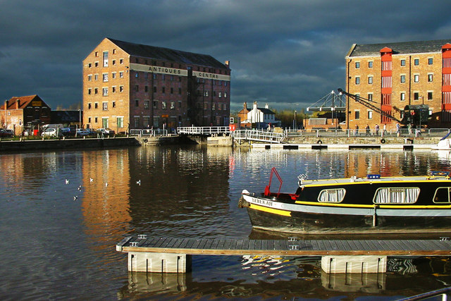
The walk starts at the 11th century Gloucester Cathedral, just to the west of the train station. From the cathedral you head south to the Docks and the Main Basin on the canal. The docks are home to the National Waterways Museum where you can learn about the fascinating 200-year history of the docks and the Gloucester & Sharpness Canal. The docks are the most inland port in the country and include old dock buildings, designer shops and cafes. From the docks you can then follow the towpath south past High Orchard, St Pauls, Monk Meadow Dock and Hempsted Bridge. You then leave the canal to link up with the Severn Way and follow the riverside path back into the town centre.
Postcode
GL1 2LX - Please note: Postcode may be approximate for some rural locationsGloucester Ordnance Survey Map  - view and print off detailed OS map
Gloucester Open Street Map  - view and print off detailed map
Gloucester OS Map  - Mobile GPS OS Map with Location tracking
Gloucester Open Street Map  - Mobile GPS Map with Location tracking
Walks near Gloucester
- Gloucester and Sharpness Canal - Enjoy cycling and walking along the towpath of this lovely canal in Gloucestershire
- Severn Way - Follow the River Severn from its source at Plynlimon in Powys, to Bristol, the mouth of the river
- Robinswood Hill Country Park - Robinswood Hill country park is located in Gloucester, just to the south of the city centre
- May Hill - Climb this hill on the Gloucestershire/Herefordshire border for wonderful views over the two counties, the Forest of Dean and the River Severn
- Glevum Way - This circular walk takes you through the suburbs, countryside and villages around the city of Gloucester.
The walk starts at Gloucester's Victorian docks next to the Gloucester Waterways Museum which tells the story of England's canals and rivers - Highnam Court - Enjoy a stroll through Highnam Park and Highnam Court gardens on this short walk in Gloucester
- Highnam Woods - Follow the 2km nature trail through this pretty RSPB reserve near Gloucester and Maidenhall
- Crickley Hill Country Park - A short circular walk around Crickley Hill country park near Birdlip in Gloucestershire
- Prinknash Abbey Park - This delightful bird park in the Cotswolds has nice walking trails taking you around a series of pretty ponds and woodland
- Cranham Woods - This circular woodland walk in the Cotswolds visits Cranham Woods, Buckholt Woods and Coopers Hill
- Pittville Park - Enjoy a short waterside walk or cycle around this pretty park in Cheltenham
- Slimbridge Wetland Centre - Enjoy a stroll around this super nature reserve between Bristol and Gloucester
- Buckholt Woods - This walk visits Buckholt Woods and Rough Park Woods near Cranham in the Cotswolds in Gloucestershire.
Pubs/Cafes
At the docks you could stop off at Dr Foster's Waterfront Bar & Restaurant. There's a large conservatory with views to the water and a good menu here. You can find them at the Kimberley Warehouse with a postcode of GL1 2ES for your sat navs.
Dog Walking
The canal and river trails make for a fine dog walk and Dr Foster's mentioned above is also dog friendly. The nearby Robinswood Hill and Highnam Woods are also popular dog walking spots near the city.
Further Information and Other Local Ideas
On the southern outskirts of the city there's the splendid Robinswood Hill Country Park to visit. There's miles of woodland trails and a fine viewpoint with views over the city to the surrounding hills and countryside.
For more walking ideas in the area see the Cotswolds Walks, the Malvern Hills Walks and the Gloucestershire Walks pages.
Photos
Cloisters at Gloucester Cathedral. The cathedral is considered one of the greatest medieval religious buildings in the country. It includes grand Gothic architecture, a 225 foot high central tower that is visible across the city and the elaborate fan vaulting of the cloisters pictured here.
Gloucester from Robinswood Hill. Part of the city centre, with the cathedral prominent. In the distance, about 20 kilometres away, are the Malvern Hills.


