National Cycle Route 47
![]()
![]() This signed Sustrans cycle route runs through Wales from Newport to Fishguard.
This signed Sustrans cycle route runs through Wales from Newport to Fishguard.
The route passes through Carmarthen, Llanelli and Swansea before finishing on the coast at Fishguard. Highlights include a stretch through the lovely Pembrokeshire Coast National Park and a series of traffic free coastal sections.
NCN 47 also forms part of Celtic Trail West, an epic 215 mile trail through West Wales.
N.B The route includes a section on National Cycle Route 4 between Warren Hill (south of Neath) to Swansea and Llanelli where you pick up route 47 again.
See the list below for manageable day rides along the route. Scroll down further for route videos and the full gpx download file.
Cycle Routes along National Cycle Route 47
- Newport to Caerphilly - This ride follows National Cycle routes 47 and 8 from Newport to Caerphilly
- Newport to Swansea - This route follows National Cycle Route 47 from Newport to Swansea.
- Newport to Pontypridd - This ride follows National Cycle routes 47 and 8 from Newport to Pontypridd
- Swansea to Pontypridd - Travel through the beautiful Rhondda Valley along National Cycle route 47 and enjoy fabulous views of the Brecon Beacons
- Carmarthen to Fishguard - Follow National Cycle route 47 on this challenging route through some beautiful countryside and the Pembrokeshire Coast National ParkThe ride starts with a pleasant run along the River Towy in Carmarthen before heading through rural Carmarthenshire and into the Pembrokeshire Coast National Park
- Carmarthen to Llanelli - This challenging the ride takes you along National Cycle route 47 through the beautiful Welsh Valleys
National Cycle Route 47 Ordnance Survey Map  - view and print off detailed OS map
National Cycle Route 47 Open Street Map  - view and print off detailed map
National Cycle Route 47 OS Map  - Mobile GPS OS Map with Location tracking
National Cycle Route 47 Open Street Map  - Mobile GPS Map with Location tracking
Cycle Routes and Walking Routes Nearby
Photos
Approaching Fourteen Locks from the west. The towpath at this point is part of National Cycle Route 47 and also the Sirhowy Valley Walk.
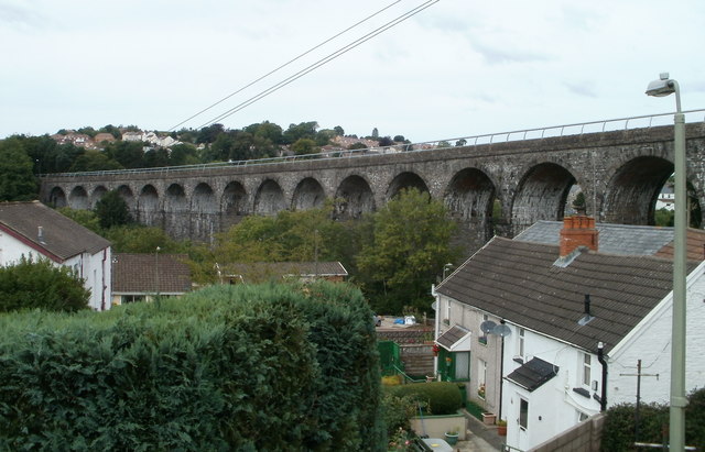
Former railway viaduct, Maesycwmmer. Viewed from Main Road, Maesycwmmer looking past houses on Thomas Street. The viaduct, now part of National Cycle Network route 47, formerly carried a railway line. 15 of its 16 arches are in view. It was built in the 1850s to carry the Taff Vale Extension of the Newport, Abergavenny and Hereford Railway over the Rhymney valley. It closed to railway traffic in 1964. It has 16 arches, is 284 yards long and 120 feet high. In 2000 it was opened for public access and is now part of National Cycle Route 47, the Celtic Way Cycle Route and the Rhymney Valley Ridgeway Walk. In the foreground, the Butchers Arms is obviously undergoing renovation.
Bicycle route signpost. Cycleways meet and diverge with three possible directions: to St David's, to Cardigan or to the ferry port (visible in the background). The numbers in red refer to Sustrans routes.
Cycle route along an old railway line. This is part of Sustrans national cycle route 47 which at this stage follows an abandoned railway line for several miles. A Dudgen type mile post (one of only two of this type in Wales) can be seen giving directions to Llanelli and Porthyrhyd. The plaque in front of the post is a Welsh translation of some English text on the post.
Monmouthshire & Brecon Canal (Crumlin arm). For a short distance the Crumlin arm of the Monmouthshire and Brecon Canal, the Sirhowy Valley Walk and National Cycle Route 47 run alongside Cefn Road the B4579 at Rogerstone.


