Nesscliffe Hill Country Park
![]()
![]() Enjoy woodland trails, heather covered hills and wonderful views over the Shropshire countryside and Welsh hills in this country park near Shrewsbury.
Enjoy woodland trails, heather covered hills and wonderful views over the Shropshire countryside and Welsh hills in this country park near Shrewsbury.
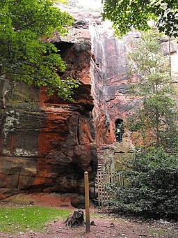
Other features in the park include an Iron age hill fort and Kynaston's cave - a cave hewn into the sandstone, said to have been the hideout of medieval outlaw Humphrey Kynaston. It's a lovely area for walking and cycling with waymarked trails to follow through the woodland.
You can continue your walking in the area by trying our Shrewsbury River Walk and visiting the delightful Quarry Park.
Postcode
SY4 1DB - Please note: Postcode may be approximate for some rural locationsNesscliffe Hill Country Park Ordnance Survey Map  - view and print off detailed OS map
Nesscliffe Hill Country Park Open Street Map  - view and print off detailed map
Nesscliffe Hill Country Park OS Map  - Mobile GPS OS Map with Location tracking
Nesscliffe Hill Country Park Open Street Map  - Mobile GPS Map with Location tracking
Pubs/Cafes
The Old 3 Pigeons is located in a convenient spot on the western side of the park. The inn has an interesting history dating back 1405 with their most notorious patron being Sir Humphrey Kynaston; Shropshire's answer to Robin Hood. From 1491 to 1518 Humphrey lived the life of a highwayman. He had a reputation of robbing the rich and giving to the poor, and in return the locals protected him giving him and his horse food. Today the pub serves good quality food and has a nice garden area for warmer days. You can find the inn at postcode SY4 1DB.
Dog Walking
The woodland and parkland trails are ideal for dog walking so you'll probably meet other owners on your visit. The Old 3 Pigeons mentioned above is also dog friendly.
Further Information and Other Local Ideas
Head a mile south to Wilcott and you can pick up the Severn Way. This significant waymarked trail could be followed west to Melverley and Crewgreen where you can enjoy views of the River Severn and River Vyrnwy. If you continue west it will take you to Breidden Forest where you can climb to the viewpoint Rodney's Pillar.
To the north there's the 13th century moated castle at Whittington to explore.
Cycle Routes and Walking Routes Nearby
Photos
Nesscliffe Hill Country Park. The abseiling cliff looking south. Nesscliffe Rock is a large sandstone outcrop in an otherwise fairly flat landscape. There is an ancient hill fort on the rock and a man-made cave within the cliff.
View WNW from the hill. The left-hand end of the ridge in the distance is Llanymynech Hill
View from the top. The peak in the distance is Caer Caradoc, about 16 miles away in SO4795, near Church Stretton.


