Shrewsbury River Walk
![]()
![]() A circular walk around the attractive town of Shrewsbury, visiting the River Severn, Shrewsbury Castle and The Quarry park.
A circular walk around the attractive town of Shrewsbury, visiting the River Severn, Shrewsbury Castle and The Quarry park.
The walk starts next to the train station at Shrewsbury Castle. The red sandstone castle dates from the 11th century and sits on a hill directly above the station. You can explore the castle grounds for free or, for a fee, visit the museum which includes regimental pictures, uniforms, medals, weapons and other equipment from the 18th Century to the present day.
After exploring the castle the walk heads around the station to the river where you can pick up the Severn Way.
Follow the path south to the Grade II listed English Bridge. You can cross the bridge to visit the pretty Abbey Gardens and Shrewsbury Abbey, which was founded in 1083.
The path then follows the bend of the river to The Quarry park. The 29 acre park was created in 1719 and includes the Dingle, a former stone quarry, now a beautiful landscaped sunken garden. There's also lovely wide lawns, ponds with fountains and the noteworthy War Memorial. This consists of an impressive bronze winged and armoured statue of St. Michael.
The park is also home to the popular Shrewsbury Flower Show which takes place every August.
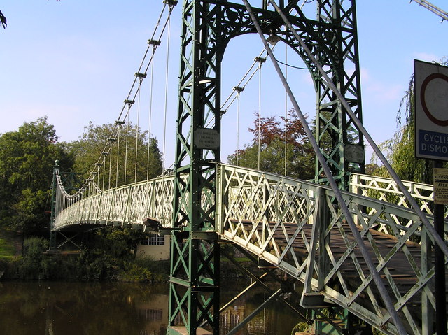
After exploring The Quarry the route then returns to the river, where you cross the Porthill Bridge to the opposite side. Here you will pass The Quantum Leap, a sculpture created to celebrate the bicentenary of the birth of evolutionist Charles Darwin, who was born in the town in 1809.
The route then passes the 18h century Welsh Bridge before crossing the river and heading through the town centre. You'll pass the noteworthy Shrewsbury Library which was the home of Shrewsbury School from 1550 until 1882. Soon after you return to the castle and the finish point of the walk.
To extend the walk simply continue north along the Severn Way. You'll soon come to Haughmond Hill where there's a number of woodland walking trails and a fine viewpoint over the town.
Continuing along the river will soon bring you to Attingham Park where you'll find deer, a beautiful Walled Garden and the River Tern.
The nearby village of Pontesbury has some nice trails to Pontesford Hill and Earl's Hill. The nature reserve has lots of flora and fauna and splendid views from the hill top. Just north of the town you can visit the site of the Battle of Shrewsbury on the Battlefield Shrewsbury Walk.There's also footpaths along the old Shrewsbury Canal and the long distance Shropshire Way to try.
Shrewsbury River Walk Ordnance Survey Map  - view and print off detailed OS map
Shrewsbury River Walk Open Street Map  - view and print off detailed map
Shrewsbury River Walk OS Map  - Mobile GPS OS Map with Location tracking
Shrewsbury River Walk Open Street Map  - Mobile GPS Map with Location tracking
Walks near Shrewsbury
- Shrewsbury Canal - This cycling and walking trail follows the route of the Old Shrewsbury Canal from the centre of Shrewsbury to Haughmond Hill at Uffington.
The path starts at Castle Fields, just to the north east of the train station - Shropshire Way - This walk takes you through some of the most beautiful countryside in Shropshire
- Severn Way - Follow the River Severn from its source at Plynlimon in Powys, to Bristol, the mouth of the river
- Haughmond Hill - Enjoy a series of waymarked walking trails in this woodland area near Shrewsbury
- Attingham Park - A circular walk around this lovely deer park in Shrewsbury.
- Hawkstone Park - This spectacular park in Shropshire covers 100 acres and includes intricate pathways, ravines, arches, bridges, towering cliffs and follies
- Pontesbury and Pontesford Hill - This circular walk from the village of Pontesbury climbs to Earl's Hill and Pontesford Hill for lovely views over the Shropshire countryside
- Grinshill - This circular walk visits Corbet Wood and the viewpoint at Grinshill, near Shrewsbury
- Battlefield Shrewsbury Walk - This walk explores the Battlefield Heritage Park, just north of the Shropshire town of Shrewsbury
- Nesscliffe Hill Country Park - Enjoy woodland trails, heather covered hills and wonderful views over the Shropshire countryside and Welsh hills in this country park near Shrewsbury.
- Hodnet - This walk visits the pretty Shropshire village of Hodnet


